-
我国海上风电资源丰富,集中在东部沿海经济发达省份,《中国风能发展路线图2050》预估5~50 m水深的风能资源技术开发量为500 GW,是沿海地区可再生能源的重要新生力量[1]。与陆地水电或风电工程相比,海上风电工程的难度更大,随着国家补贴退坡,海上风电进入平价阶段,对高难度高投入的海洋工程实现降本增效是现阶段最大挑战。
海洋工程技术主要包括地质勘察工程技术、结构工程技术、岩土工程技术、建造技术以及运营维护技术5部分。海洋地质勘察技术(以下简称“海洋地勘”)是指通过勘察工具和数据处理获取有关海床地形、地貌、地层分布及岩土工程特性等客观信息和数据的技术。鉴于海洋工程高技术、高投入、高风险的特征,海洋地勘数据的完备性和可靠性是实施开展海洋开发和工程建设的内在要求。使用适当的现场调查和分析技术可获得以下成果:(1)减少了现场调查的规模;(2)减少了项目成本、计划和风电场总资本支出(CAPEX);(3)减少了因对开发项目进行调整而产生的额外工作,例如修改风机布局或微调单个风机[2]。
地勘数据的完备性是用于回答数据“是否够用”的问题,具有空间覆盖是否充分以及测试内容是否全面的要求。海洋地勘的对象是千变万化的海床环境,海洋开发通常覆盖的区域较大,但是海洋地勘中定点勘测成本高、难度大,单位面积勘测密度远低于陆上工程。为了在合理成本下保障地勘数据的充分性,海洋地勘通常把定点式岩土工程勘测与区域性工程物探整合起来,建立区域性工程地质模型[3],从而由点到面,实现对区域沉积环境具体而微的认知。另一方面,为保障海洋地勘数据测试内容的全面性,则需勘察与设计的深入协同,保证勘察工作有的放矢。
海洋地勘数据的可靠性则是回答数据“是否正确”的问题,具有以下2个基本要求:(1)数据的离散性小,以使海床土体与海工基础结构的相互作用分析(例如海上风机的共振和疲劳分析)更具可行性;(2)数据相对“真实值”无显著偏离,保障海工基础设计与安装的安全性。海洋地勘测试包括多个环节,受作业环境、仪器设备、人员、作业工艺等多方面的影响,单个环节产生的测试误差在系统内传递并积累。另一方面,土体是非线性多相粘滞性材料,物理力学特征有多方面的表达,而且每处土体的沉积环境和沉积历史独特,难以确定其物理力学特征参数的标准值或者真实值,导致勘测误差难以辨认。因此,如何保障数据的可靠性及精准性是海洋地勘的难点。
由于海洋开发特殊的作业环境、工作内容和要求,海洋地勘与陆上勘察有显著不同的技术理念、技术路线和实施方法[4-5]。当前,我国提出通过智能化、数字化和信息化等高科技手段,解决传统能源行业普遍存在的共性问题,促进能源产业升级,推动行业高质量高效率发展的战略[6]。人工智能、大数据、数字孪生也被认为能为海上风电工程规划设计、施工、运维全生命周期提供数字化解决方案[7-8]。然而,我国地勘特别是在海上风电领域,受陆上线性、经验式的技术路线影响较为严重,地勘结果普遍存在多解性,出现离散性大、严重偏离真实值的现象,“地勘数据是说不清楚的”已成为工程常态[9-10]。因此,不仅各种高科技手段在智慧能源行业的定义和应用架构仍有待深入研究,而且首先要解决数据的可靠性及完备性[11]。强调数据一致性分析的人工智能技术已经在医学、铁路等工业领域得到应用[12-14]。
即使在起步较早,相对成熟的欧洲风电市场,海风地勘也有其自身的限制和挑战。例如,很多大型风电场场地可能存在复杂多变的地质条件,不准确的地勘数据可能会在项目生命周期的后期产生严重后果。2013年,综合考虑了复杂地质条件和其它不利因素,英国放弃了2个海上风电项目[15],突出了地质条件对海上风电场的潜在影响。为保障海上风电项目的顺利进行,保证海洋地勘数据的完备性和可靠性,亟需在一致性原则的基础上,建立交叉立体的海洋地勘测试流程和工程地质模型,一方面确保各个测试环节的严谨性,另一方面可以对地勘数据去芜存菁,保障地勘特征参数的可靠性和精准性,最终助力风电项目实现高效设计、施工、维护和退役,从而达到全生命周期的降本增效。
-
工程地质模型是为解决工程问题而创建的地质条件近似,包括地质特征模型和工程特征模型。早期讨论认为岩土工程的复杂性来自地质条件变化和改变的过程,而这些复杂过程是可以通过工程地质模型来描述[16]。模型应该解释一般的属性组合并帮助地质学家或岩土工程师了解岩土在横向和纵向的改变、预测未测量点的特征。随着岩土工程及其模型得到了更广泛的应用,研究人员对模型进一步分类为:地质模块,岩土参数模块和岩土物理数学模块[17]。当前国际上的海洋地勘发展趋势[18-20]愈加重视工程地质模型为一整体,并与区域性工程物探、定点式岩土工程钻孔取样和原位测试的深度整合。
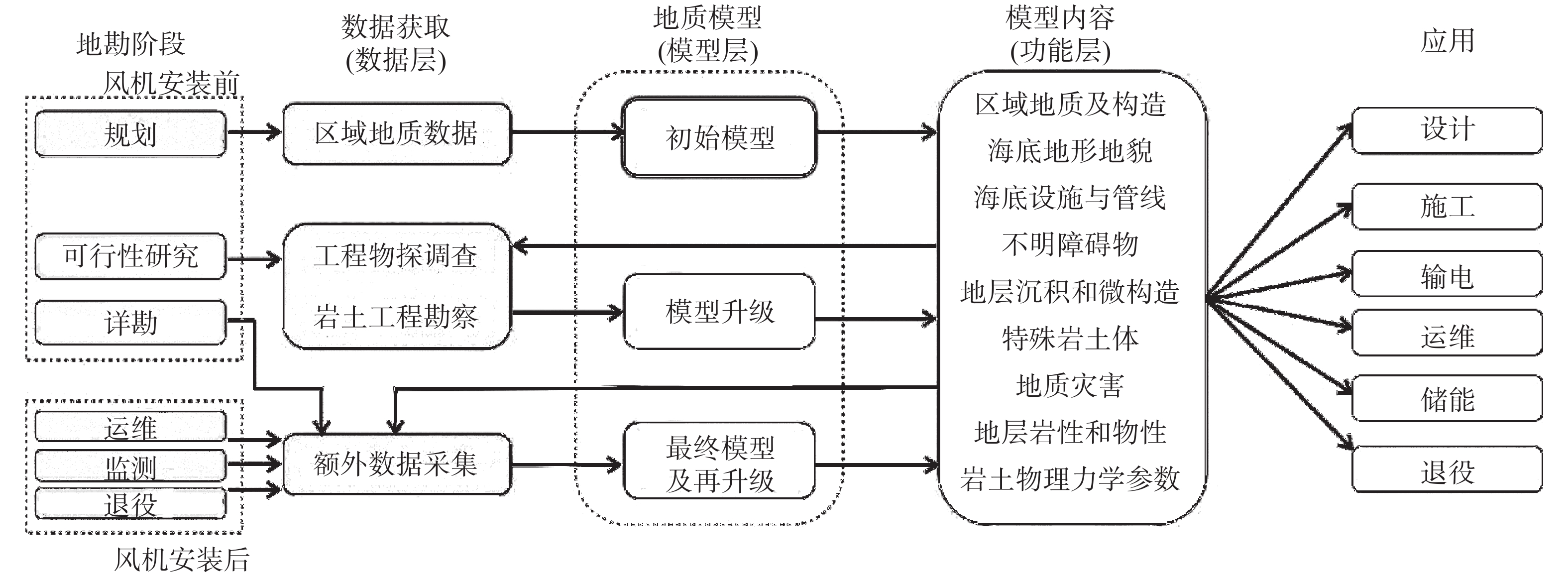
随着工程的不断推进,工程地质模型也是不断迭代完善且价值得到进一步提高(图1)。一个好的工程地质模型在规划阶段为初步概念模型、预测了地质条件和潜在地质灾害,为后续可行性研究阶段的海上勘察提供信息。当实施了岩土和物探调查,获得了更多数据,通过数据分析和解释,包括地层识别、相关层岩性和物性分析、力学特征和特殊地质条件解释,工程地质模型得到了完善,成为判断地质灾害工具,为基础设计的岩土剖面和参数值评估提供重要信息。在详勘阶段,地质模型与原位和实验土工测试数据进一步一起使用,用于细化微观场地结构,预测微观土层性质,并将工程特性与设计联系起来。在全海风周期中,岩土和物探数据还将不断被采集,因此模型也将不断被改进。
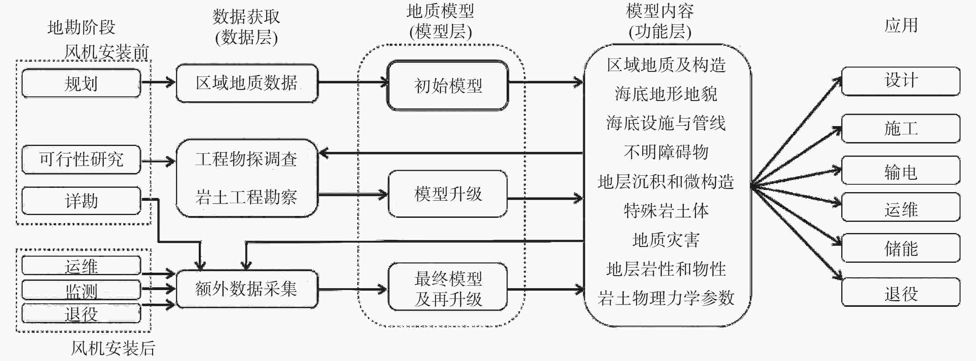
图 1 海风地勘实施与工程地质模型构建流程图
Figure 1. Flow chart of offshore wind power geological survey and engineering geological model construction
所有不同阶段地勘的共同点是表征海床岩土地质和力学特性[21]。工程地质模型应被视为随着更多数据可用而不断开发和更新的三维模型(图1)。初始概念模型从规划阶段的桌面研究开始,以三维观测模型的形式开发,该模型结合了已有的岩土勘察和工程物探调查的数据和结果。工程物探调查应在岩土勘察之前进行,其结果为岩土勘察工作设计提供依据。工程物探调查当前标准是获取1个密集的二维网格,包括多波束、浅层剖面和单道地震等,在此基础上可构建三维体显示[22]。至关重要的是,工程地质模型必须建立在海洋地勘一致性理念上并充分结合了物探和岩土数据。模型的建立[23]必须由地勘数据专家对可用数据进行的整体一致性解释,而不是孤立地对单个数据集进行解释。在一致性理念基础上,即使仅有基本的三维地面模型和场地范围内的初步岩土特征,也可以进行早期的地基设计工作并绘制适合地基类型或尺寸的许可区域地图[24]。
-
基于一致性原则的海洋地勘技术包括2个层次:(1)单一勘测环节需要遵循自身的操作流程,满足各个专业规范;(2)在勘测体系上,对于同一测试值,形成多种“独立”方法之间的相互校核。本文更加重视后者即体系的建立,所探讨的海洋地勘的一致性包括3个方面的内容:(1)岩土勘察数据的一致性;(2)工程物探数据的一致性;(3)工程物探与岩土勘察数据的一致性。
岩土工程勘察是指通过钻探取样或者原位测试的方法,获取指定点位指定深度海床土体的物理力学信息。其中,海床土体的力学强度特征,特别是静载条件下粘性土的不扰动不固结不排水强度Su和砂性土的内摩擦角
$\phi $ ,是海洋工程最直接、最基本的勘察参数,也是最容易受到外界影响而出现较大偏差的参数。勘测的目的是增加和进一步迭代已有初始工程地质模型,确定海底条件垂向和横向变化,并为基础设计提供相关的岩土数据,以规划风机安装、操作和维护以及规划电缆保护和/或掩埋。以下着重讨论岩土勘察数据获取方式和船只选择对地质模型的影响,一致性数据分析方法已在另外一篇文章阐述[25]。 -
岩土工程勘察通常先在初始工程地质模型基础上起草作业方案,根据现场的地质条件(例如地层、水深和地质灾害)、项目的需要、可选项适用/限制以及一致性原则,方案涉及了:工程钻探、取样和原位测试、岩土实验室试验和测试。需要注意的是,随着现场数据的不断获取,可用信息增加和现场作业条件改变,岩土勘察作业方案计划应由经验丰富的岩土工程师根据工程地质模型在必要时现场修改。
常用的海上工程钻探平台类型有船式和自升式钻井平台,船式又分为动力定位(DP)和四锚定位钻井船2种。每种方式都有自己的优缺点。最佳的选择取决于多种因素,而且因素在大多数情况下是特定于具体的站点或项目。例如,如果水深小于30 m,则不能使用DP船。但如果综合考虑成本、收益和作业周期等因素,船式钻机平台有着更多的优点和更大的适用范围。
当前,我国海洋岩土勘测普遍采用以钻孔取样测试为主、以原位测试为辅的测试方法。其中,静力触探(CPT)是最为常用的海洋岩土原位测试工具[21]。CPT通过锥形探头内的传感器测量在推动过程中产生的尖端阻力、套筒摩擦和孔隙压力,探头安装其它传感器后,还可测量温度、电阻率、波速等物性参数。与各种岩土取样的离散性相比,CPT允许获得不同土体特性的连续剖面,是工程地质模型必不可缺的数据之一。测量结果不仅可用于评估土层的岩土行为类型(SBT),还可通过工程地质模型估计其它各种工程参数[26]。
实验室试验和测试的复杂程度和差异性很大,即包括可以在几分钟内轻松可靠地在海上进行的常规测试,同时也有从海床中提取样本后,需要数周转运并在高度专业化的陆上实验室进行的高级岩土测试。所有情况下,重要的是要获取工程地质模型所需的足够样品,以便建立试验测试结果和CPT参数的相关性并准确了解风机基础研究所需的不同岩土特性。无论保存和运输过程多么小心,一些样品可能会在运输过程中损坏或受损,而样品是无法修复的。因此,充分考虑船期、费用、天气等因素,确保收集的合格样本数量超过初期工程地质模型推算的数量是关键。
-
在取样测试中,由于围压的存在,海床土样的扰动是不可避免的,土样扰动可显著改变土样原本的强度和变形特征,是影响海洋地勘质量的关键因素[27]。如果海洋风电地勘采用陆地式钻机+自升式平台这种装备组合获取土样,容易导致土样的较大扰动,在后续土样保存、运输及操作环节,再缺乏针对性的保护措施,其产生的土样扰动将直接影响后续的岩土测试。此外,岩土测试自身也容易产生偏差。考虑到海床物理力学特征的标准值/真实值难以确定,如果勘测各环节技术手段单一,例如土体的Su强度仅通过常规三轴试验量测,仅仅依赖单一测试,则难以对勘测结果的可靠性做出评判。基于一致性原则的海洋岩土勘测技术充分考虑了土样扰动并对土体强度等测试结果的一致性进行综合评估,有效避免土样扰动等因素对土体测试的干扰[28]。
物探设备的选择可以显著增强后续的岩土勘察效率。使用物探数据资料来预先评估风险和特征地质条件,在关键地质区域进行钻孔或现场测试。反之,在未评估的现场,如果设备被认为不适合于现场条件,将影响现场获取高质量岩土数据,也有可能延误工期。为了满足岩土工程设计要求,海上风电场的现场调查总是涉及原位测试、土样采集和现场及陆上实验室测试。借助工程地质模型规划原位和陆上实验室测试,可以显著节省成本和时间,并有助于保持原位和实验室测试的一致性。
增加测试数据的有效性和利用率也可以通过工程地质模型最大化,通过将物探剖面与岩土探孔相结合,即能确保满足风电场场地基础设计的要求,也能通过不同土层间适当布置,在保证数据一致性的基础上,有效减少同一土体间的重复实验室测试。另外,在样品回收率低、高级实验有限但有现场原位测试数据的情况下,通过对少量实验室测试结果与原位测试一致性研究,利用工程地质模型为未有实验室测试的土层提供可以接受的预测值。
-
海上风电工程物探勘察主要目的是获取风场详细地质数据,构建清晰工程地质模型,从而分析预判可能地质灾害和确定潜在的施工危险。结合工程地质模型,物探勘察获取的高分辨率多波束测深和旁测声纳数据可识别沉船,磁力梯度仪数据可识别不明爆炸物(UXO),浅层剖面、电火花和高分辨率多道地震数据可识别浅层气和复杂地层,三维电火花和超高分辨率地震数据可识别埋藏孤石和局部砂体。图2显示某风电场海底表面的人工鱼礁。物探设备一致性分析研究是减少物探方法的多解性和确保清晰明确工程地质模型的关键和重要手段。
-
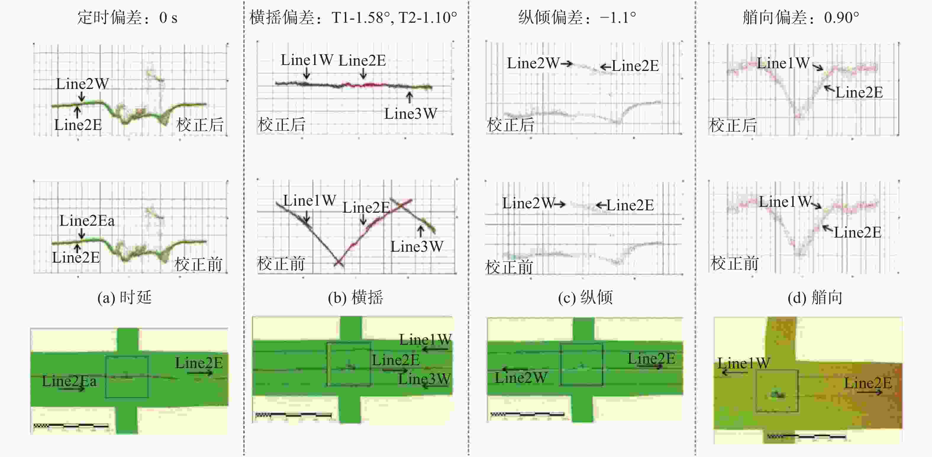
海洋工程物探包括多种调查方法和设备。对每一个工程物探设备,特别是水深测量设备都须遵循设定程序进行一致性标定,在一个给定已知点对设备和搭载平台进行多次测试,即静态校正。其目的是效验船只和设备的参数。标定结束后,设备还需通过自身的交叉走航测试对设备在搭载平台不同姿态进行实际验证,即动态校正。例如,应用广泛的多波束,动态校正还旨在解决设备和其相关外部传感器的一致性。通过重复收集和处理一些特定数据,多波束传感器的横摇和纵倾以及延迟和偏航等细微的偏差将能够被修正,达到一致性效果。图3显示一致性校正后,多波束数据精度得到提高。一致性校正前,特别是横摇,不同测线之间的数据互为噪音。
多波束一致性校正应按“时延—横摇—纵倾—艏向偏差”的顺序进行,且在进行下一个参数校正时要先输入已校正好的值,以排除校正时其他参数的影响。为保证测量的精度,每组校正至少需进行3次,按规范要求,经多次测量后标准误差应满足:定位时延±100 ms;横摇偏差±0.1°;纵倾偏差±0.1°;艏向偏差±0.1°[29],如果是浅水多波束要求更严格[30]。校正应在每个地勘项目数据采集前进行,如在野外作业过程中,船体有明显改变、换能器或涌浪补偿仪位移、测线间重合不好时,应重新进行参数的一致性校准。为便于不同测线数据间的比对,检验区域的海床应具有一定的坡度、地貌特征或水下沉船以增加辨识度(表1)。另外需要指出的是原始测试和采集数据应充分保存、备份和管理,测试结果应输入到工程地质模型中,便于查证和从新校正。
表 1 多波束一致性校正类别和要求
Table 1. Types and requirements of multi-beam consistency correction
类别 线长/m 海底地形特征 测线特征 航行速度/方向 一致性分析目的 定位时延 500~1 000 海底地形坡度
(10°~30°)同线、同向 船速相差1倍以上 消除船速对测量的影响 横摇偏差 500~100 平坦海底 同线、反向 相同船速 消除仪器横向倾角对测量的影响 纵倾偏差 500~1 000 海底地形坡度
(10°~30°)同线、反向 相同船速 消除仪器纵向倾斜对测量的影响 艏向偏差 500~100 斜坡或其他特征地形 不同线(线距大于最大条带宽带)、反向 相同船速 消除仪器安装艏向偏差对测量的影响 -
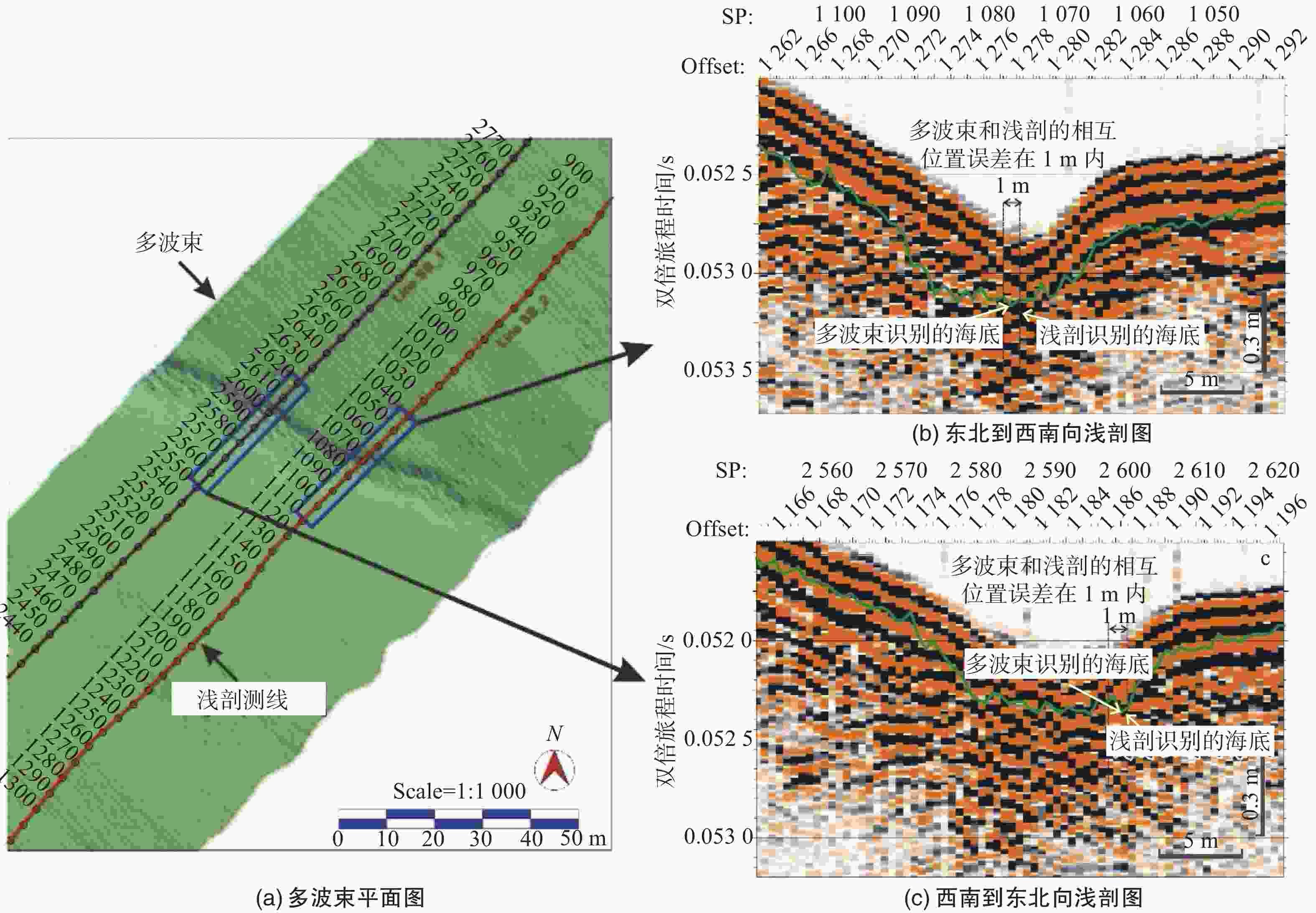
工程物探技术方法多样,但其目的都是通过获取的数据资料来查明工程地质模型,即海床地形地貌特征、地层变化、地质构造及其展布规律等地质情况(BOEM2014,2015)。在考虑不同设备方法在空间或频率局限性的同时,也应充分认识到不同方法对同一地质模型的测量结果应具有一致性。以声学为例,多波束测深设备是了解水深变化和海床地形、地貌特征等地质模型表层的主要技术手段,相对单波束测深,具有测量范围大、高精度、高密度和高效率的特点。系统已实现浅水到深水的全海域水深测量,其中用于海上风电的浅水多波束系统测量精度达5 cm(图3)。多波束测深主要工作频率在10 kHz的深水系统到400 kHz浅水系统范围内,由于超高的频率,声波基本没有穿透能力,不能反应地质模型海床以下的地层信息(表2)。浅层剖面测量是利用声波穿过不同的地层时存在界面反射特性来反映地质模型属性。应用比较广泛的浅地层剖面仪主频约为1.4~4.5 kHz;穿透深度通常在20~30 m;垂向分辨率最高可达0.1 m[31]。海床是浅层剖面的第一层反射界面,对比多波束和浅层剖面,虽然是两个频率不同的设备,但通过时声转化后得到的浅剖深度数据应与多波束一致,例如图4显示两者的横向一致性在1 m内、垂向一致性在0.15 m内。
表 2 地勘声波设备主要勘探参数
Table 2. Main exploration parameters of acoustic equipment for geological exploration
方法 用途 主频 垂直分辨率 穿透深度 多波束 海底地形地貌 200 kHz n/a 10 cm 浅层剖面 管线,基础调查,
风场场址勘察1.4~4.5 kHz <0.3 m 30 m 高分辨地震 地质灾害,
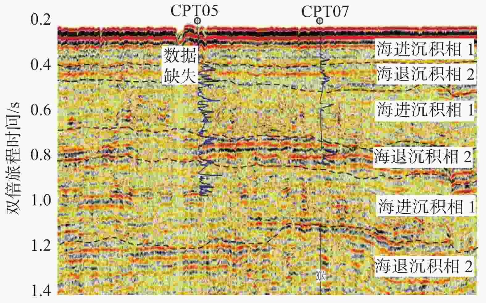
风场场址勘察150 Hz <3 m <1 500 m 常规地震 油气勘探 30 Hz <10 m >3 000 m 相对浅层剖面,单道和小道距高分辨地震测量的频率更低,能探测到更深的地层,主要用于了解工程地质模型的地层厚度、层序与结构构造以及构造运动等,成本相对传统油气多道地震要小,分辨率高。电火花震源多用于单道而单枪震源多用于高分辨率地震,两者能量小,波长短,具有分辨率高,拖拽便利,无汽包效应干扰等优点,但缺点是缺少多次覆盖,信噪比低。传统多道地震测量排列长、道间距大、海上施工复杂,通常适用于海底千米深度以下深层探测,用于探测深部地层、地质构造等;目前用于多道地震勘探基本采用多枪阵,气枪震源能量大穿透能力强。电火花数据能了解多道地震了解不到的地质模型信息,也能了解到多道地震能了解到的信息,反之亦然。因此,在工程地质模型中的多道数据应与电火花数据有一致的结果且互为补充。多设备一致性分析,不仅仅是数据间的相互验证,提高探测效果,增强对地质模型的刻画,更是弥补单一数据的多解性和数据采集的缺失。图5用沉积相一致性分析解释对比了某风场地勘中3种声波方法过同一测线的3个剖面,图5(a)为高分辨地震结果。高分辨地震可以识别出两个典型沉积相,揭示地质模型的3次海进海退沉积事件。第1套地震相以波状结构、中-低振幅、低-不连续、局部杂乱反射为特征,反映1个水动力较强、复杂的滨海-浅海相沉积环境。第2套沉积相以平行结构、中-强振幅、中-高连续为主要特征(图5(a)中的黑框和图6)。由于地震结果横向变化不大,纵向上分辨率低,此时,根据地震数据推断的地质模型较为模糊,强振幅代表沉积物粒度较粗、以强振幅为主要依据可推测该地沉积相为海平面相对下降以及陆源供应充足的三角洲陆地沉积环境;而中-高连续通常反映的是一个相对稳定的沉积低能环境,以中-高连续为主可推测该沉积相为海平面相对上升的浅海相沉积。因此,单一设备不能完全清晰刻画工程地质模型,也无法满足海风精准地勘生产需求。
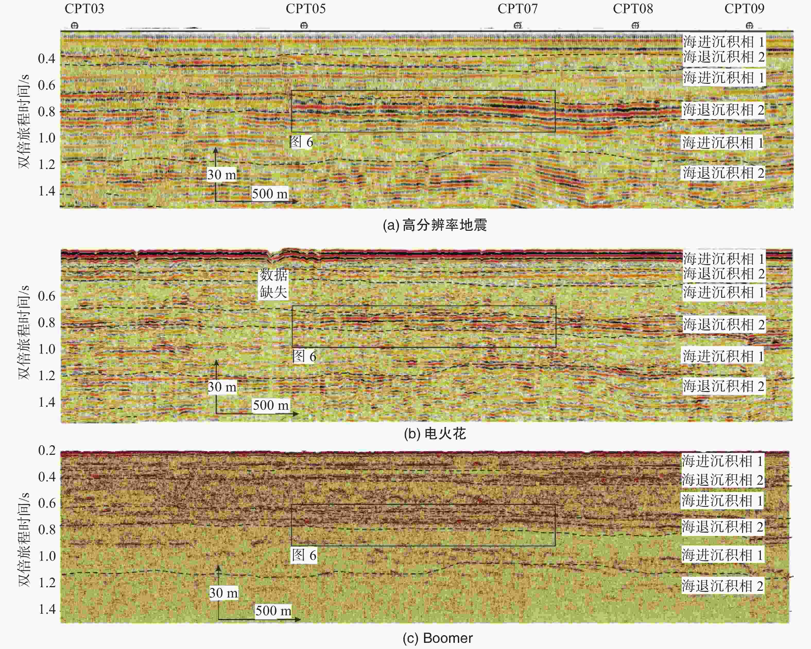
图 5 工程地质模型3次海进海退一致性分析及电火花数据缺失
Figure 5. Consistency analysis of three marine transgressions and regressions in the engineering geological model, and data missing of electric spark
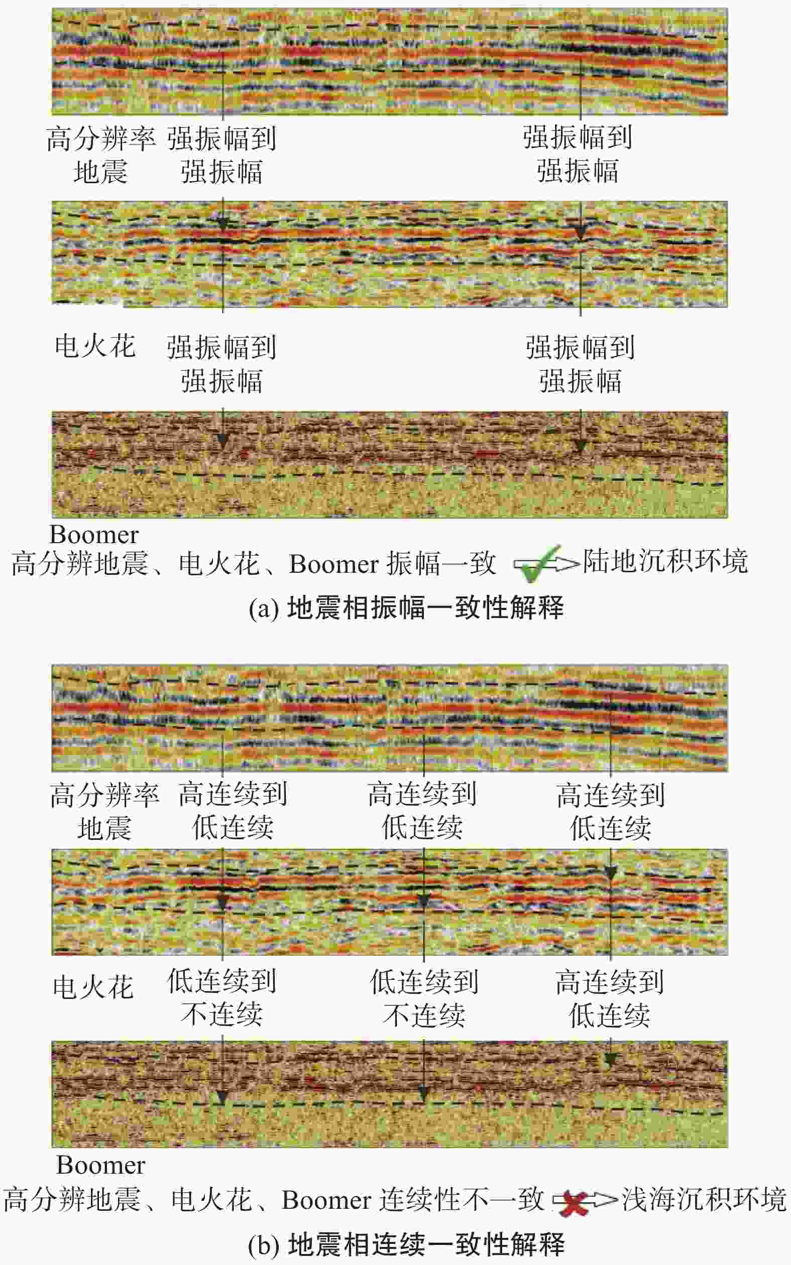
图 6 高分辨地震、电火花和Boomer振幅和连续一致性分析
Figure 6. Amplitude and continuity consistency analysis of high-resolution earthquake, electrical spark, and boomer
图5(b)为电火花剖面结果,其频率和采样率远大于高分辨地震(表2)。明显看出横向和纵向分辨率大幅提高。在第2套沉积相内,电火花更进一步清晰的显示地质模型薄层砂岩的边界和砂泥互层,确认了地震数据可靠性并解决了单一方法的多解性问题。电火花数据连续一致性分析显示第2套沉积相内夹杂低振幅、低连续反射,显示局部沉积物混杂堆积,不像是一个相对稳定的沉积环境,如图6所示。图5(c)为Boomer剖面结果,对比图5(a)和图5(b)可见,3次海进海退沉积事件分布几乎完全一致,且浅层薄砂体的可辨识性在Boomer剖面上得到提高,砂体横向不连续性更加明显。Boomer数据显示第2套沉积相内夹杂低振幅、不连续局部杂乱反射,底部边界清楚,显示三角洲陆地沉积环境、陆海交界较强冲刷的特征(图6)。因此,高分辨地震、电火花和Boomer振幅一致性分析支持陆相沉积环境解释,而地震相连续一致分析也支持路相沉积环境(图6)。同时,不同物探方法之间的交叉验证可以有效减小单一测试方法可能出现的系统误差。在电火花数据出现的海底麻坑、在地震和浅剖上并没有体现,表明麻坑为假象。电火花在此处的数据有丢失(图5)。
-
地勘包括安装前的规划、可行性研究和设计,及安装后的运维、储能和退役,是一个时间跨度的全生命周期工程。虽然也借鉴以往的成果,但传统方法将岩土勘察和工程物探分离,不同阶段的数据分析、成果和报告也是相互独立的,数据并没有得到充分利用(图7)。而工程地质模型新方法始于地勘施工计划、再到野外和实验室数据获取、再到数据分析、再到建模、之后再回到下一阶段的地勘施工计划。而且,在地质模型基础上的地勘平台系统创建了专门的数据分析系统来比较不同调查结果之间时空差异变化和一致性,将数据的时态性特征通过工程地质模型表现出来,并通过岩土和物探数据之间的相互支持、相互印证升级地质模型,提高了数据的可靠性、准确性和应用场景。
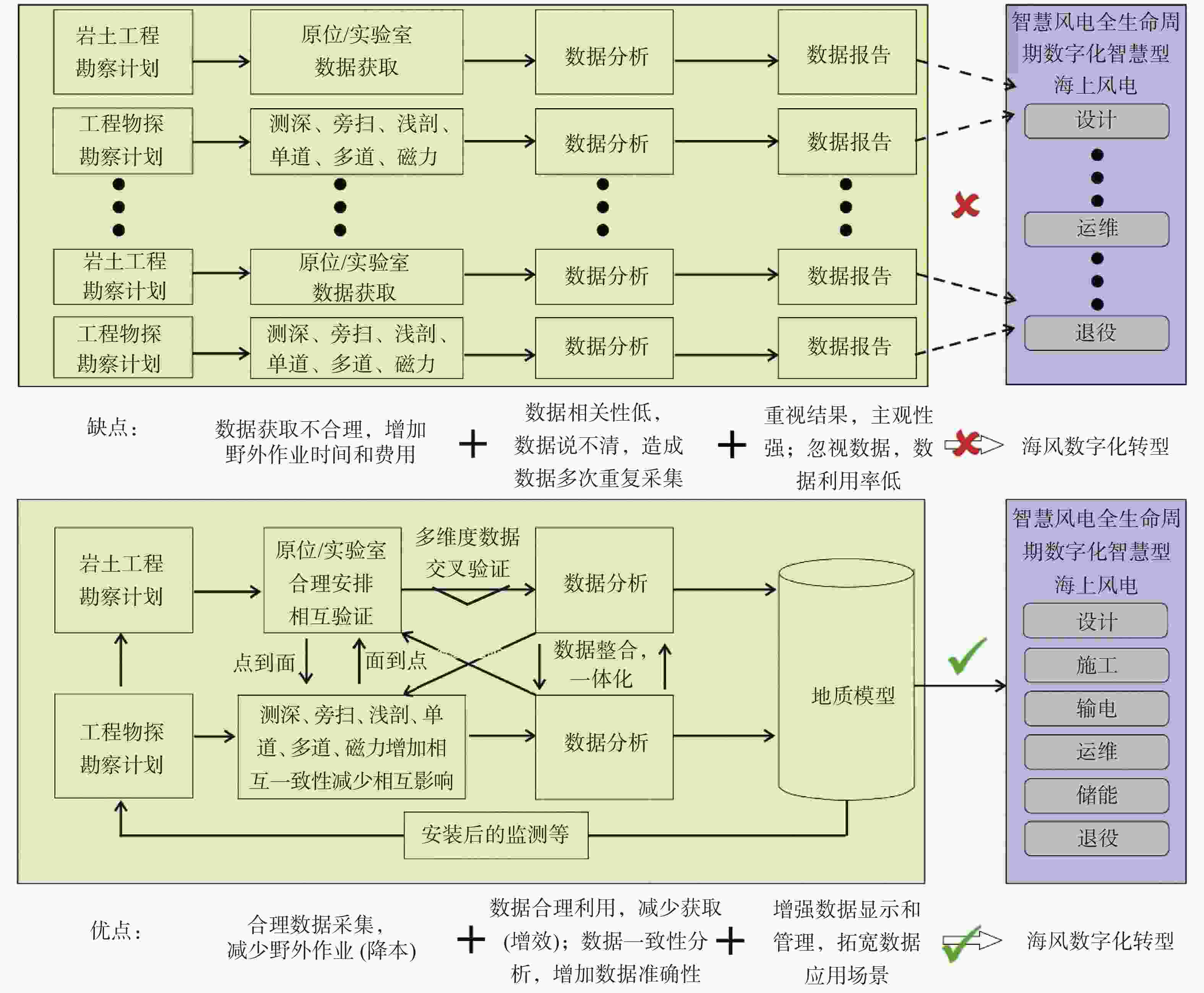
图 7 传统地勘方式与工程地质数字模型的对比
Figure 7. Comparison between traditional geological survey method and digital model of engineering geology
如图1所示,工程地质模型包括了数据层、模型层和功能层,通过地勘平台对结构化和非结构化数据分析、解释和整合形成一个完整的工程地质机理模型已经接近于“数化仿真”阶段。虽然现在数据分析和整合依然需要通过人机互动完成,但应该看到建立在地勘平台上的工程地质模型已经是工程地质数字孪生的雏形,也是构建海洋地勘基因库的基础,对其不断地创新和完善,不仅能为实际地勘工作的质量提升、效率提高提供了支持,也将成为地勘工作数字化转型的重要组成部分(图7)。传统地勘方式与工程地质数字模型的对比,新方法减少了野外作业、提高了数据精度、拓宽了应用场景,显然更适合海风数字化转型。
-
“多维度数据交叉验证”和“数据整合、一体化研究”是工程地质建模的2个重要组成部分。单一物理量仅反映工程性质的某一面向,透过多个不同物理量整合可有助于将不确定性逐步降低,增加解释的准确性。以上述Boomer、电火花、和地震声波为例,弱振幅虽可能表示其剪切波速较弱,进一步表示其剪切强度也较弱;但亦可能是反射界面不清晰,没有强速度差,界面散射较多,而不是软黏土造成的弱剪切强度。若此时有现场钻孔数据或CPT数据辅助,钻孔可直接显示其岩土种类,CPT锥尖阻力的强弱也直接反映黏土强弱,如此通过至少2种不同物理量整合判释,可使工程地质模型的不确定性大为降低。图8显示了CPT过井电火花地震剖面,CPT锥尖阻力和地震振幅一致性好,高锥尖阻力对应红色强振幅。CPT和电火花一致性分析显示海进阶段地层包含较多的砂泥互层;海退阶段地层包含较厚的砂层。
如本文开始所述,现有岩土勘察以钻孔取样为主,原位测试为辅,在此基础上,增加原位工程物探测试,在钻孔CPT测试同时,进行剪切波速以及密度钻孔测量。剪切波速应与CPT的锥尖阻力有一一对应关系,高剪切波速表示高黏土剪切强度,但并不能完全清晰描述地质模型,高波速和锥尖阻力亦可能是含有部分透水性高,粒径较大的砂石,而高密度可验证后者存在的可能性,再结合岩土试验结果进行一致性分析,不仅数据之间得到了相互验证,更将岩土试验的点数据,扩展到一个连续的深度数据,更有效的描述工程地质模型。
在野外现场岩土勘察期间的某个时间点,在收集到了物探数据之后,数据可能会揭示土层的横向和垂直连续性。如果发生不连续情况,至关重要的是在岩土勘察中增加额外的钻孔,以关联和支持物探结果。例如,许多浅层2D地震线或浅层剖面可能表现出细微不同的特征,但声阻抗(层密度x层声速)的细微差别可能对应着超出预期的岩土特性变化。
-
工程物探和岩土勘察是海洋地勘的两个重要组成部分,同时使用这两种方法为建立准确的三维工程地质模型提供了合适的解决方案。岩土勘察方法能提供准确的点数据,但耗时且成本高。虽然CPT方法直接测量土体强度并且提供高分辨率垂向数据;然而,它价格同样昂贵,且空间意义有限。物探方法则是一种间接技术,提供地质模型的地层厚度、深度和分布信息。物探技术具有采集快速且廉价的优点,但其准确性低于岩土勘测技术方法。例如地震方法在过去的几十年中在海洋地勘中发挥了重要作用。通过岩土勘察和工程物探的结合,能为现有的地勘作业方式提供更经济的替代方案,也有效解决长期困扰勘察地球物理中“物理现象本身非唯一性”问题,加之开展多方法一致性分析,可以提高探测效果,减少单一方法的多解性(图8和9)。
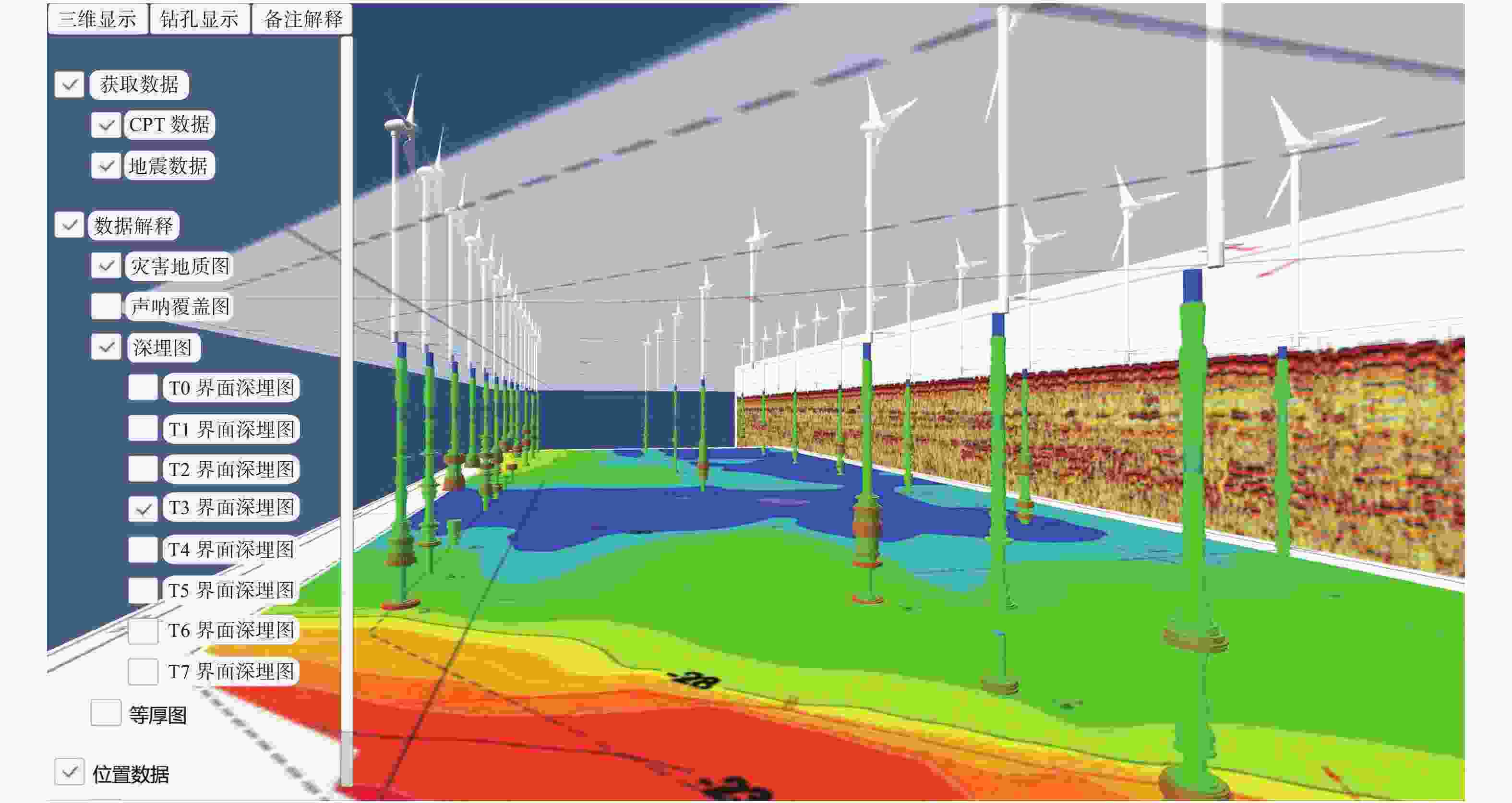
图 9 某风场地勘工程物探和岩土勘察三维一致性显示
Figure 9. Three-dimensional consistency display of geophysical prospecting and geotechnical survey in a wind farm prospecting project
海洋地勘数据有着较强的空间特征,地勘数据平台技术与工程地质模型结合可以有效的对空间数据系统进行管理、分析和显示,并保证所得出的数据具有较高的准确性和一致性。地勘数据可以是结构化ASCII或二进制数据,也可是半结构化的图表数据。图9为某风场工程物探和岩土勘测三维一致性显示,既有结构化的CPT和地震数据,也有半结构化地质解释图。风机下面地圆柱体表示CPT测量结果,蓝色表示弱锥尖阻力,红色表示强锥尖阻力。在底部T3界面等深图以上,大部分柱状体显现了一段粗的红色强阻力,在此以上,则表现为绿-蓝-绿-蓝分布,整体有很好的一致性。而且也与远处的电火花剖面表现的3次海进海退一致。顶部的灾害地质图显示断层穿过此风场场址。
工程地质模型的空间数据主要是以三维立体的方式分布,便于更为精确地处理数据和显示信息,传统的土工测量往往获取和分析的是某些选取节点的一维空间数据,物探地质成图技术虽然已经从点扩展到面。但仍然缺乏对于时空变化的分析与比较,强调横向而缺少纵向,如图9中显示的T3界面埋深图。工程地质模型具有海工全生命周期的一致性和共享性特点,不仅为接下来的安装和运维工作打下良好的保障基础,还可以实现地质模型及数据在不同专业、不同阶段之间共享。
图9仅显示了一个简单工程地质模型,后续工作将在三维工程地质模型中加入地层测试、物理、力学、动力等多维度的参数指标,及海床地质灾害如浅层气、海底滑坡、障碍物等要素,为后期风电场海工提供一个更全面的信息模型。
-
1)海洋地勘是海风开发的重要环节,为其提供完备可靠的地勘数据。区域性的工程物探、定点式的钻孔取样和原位测试、以及工程地质模型的深度整合是当前国际海洋地勘技术发展的重要趋势,也是海风降本增效的突破点之一。
2)基于海洋地勘的特征,本文提出了建立立体交叉的海洋地勘流程和不断迭代得工程地质模型新方法,形成多种数据“独立”的一致性效验和数据之间的相互校核,辨别数据的偏差,从而对地勘数据去芜存菁,保障最终数据的可靠性和精准性并形成清晰的工程地质模型。
3)本文所探讨的工程地质建模新方法包括3个方面的内容:岩土勘察、工程物探以及工程物探与岩土勘察数据的一致性,同时也包括3个阶段:规划阶段的初始模型、可行性研究阶段的模型升级、详勘阶段的最终模型及以后的再升级。
4)在岩土勘测环节,本文阐述了野外数据的最优获取方式和数据一致性综合布设, 重点强调了把室内土工试验和原位测试相结合,常规土工试验和高级土工试验相结合建模方式,和工程地质模型指导取样站位布设和取样深度选取。
5)在工程物探方面,本文建议野外作业应采用多种一致性分析技术有效地解决仪器系统误差和安装误差问题,并提出多种物探方法联合构建工程地质模型的方法,避免了对单一物探结果的错误解读、建立了更为精准的地质模型模。
6)对于工程物探和岩土勘测的联合,本文从工程应用出发,充分考虑海洋工程的多专业、多阶段、全生命周期的特点,建议在一致性分析基础上,辅助增加原位钻孔探测项目与深度,构建更清晰全面的工程地质模型。在建模中应用多种方法整合判释、尽可能进行定量分析,并利用地勘数据平台技术管理和分析时序监测数据增加额外信息和增强空间数据显示功能,从而进一步增加地勘成果和工程地质模型的可信度和适用范围, 为地勘数字化转型夯实基础。
面向海上风电开发建设的工程地质模型及应用研究
DOI: 10.16516/j.gedi.issn2095-8676.2023.04.006
CSTR: 32391.14.j.gedi.issn2095-8676.2023.04.006
Research on the Engineering Geological Model and Its Application for Offshore Wind Power Development and Construction
-
摘要:
目的 加快海上风电建设和发展对促进我国能源结构调整具有重要意义,我国正迎来全海域海上风电开发浪潮,而地勘是海风开发的重要基础和关键技术。 方法 通过研究国内外海洋地勘技术并结合多年不同海域工作经验,提出一种基于一致性原则的海风工程地质模型新技术。首先,勘察设备选定及测线布置应从三维初始模型出发,评估地质变化和地面灾害对海风设计施工的影响,并充分考虑船只选型、野外原位和室内实验测试、物探和土工数据关联。然后,在可研和详勘阶段,获取钻孔及风场全区域丰富且连续的数据后,采用室内土工试验和原位测试相结合,多物探设备结合,岩土和物探方法相结合的方式对各种数据进行一致性分析、地勘数据平台管理、模型升级和建立最终模型,并在后续阶段不断优化和迭代工程地质模型。工程地质模型为海上风电场设计,安装,运维和退役全生命周期提供全面工程地质信息。 结果 研究结果和海风地勘实例表明,通过一致性综合布设和数据分析,有效连接岩土勘察和工程物探,构建立体交叉的工程地质模型能有效解决“地勘数据说不清”问题,提高地勘数据可靠性、精准性和应用度。 结论 所提新方法是海工实现降本增效的有效方法之一,也是海风地勘数字孪生的雏形和构建地勘大数据基因库的基础。 Abstract:Introduction Speeding up the offshore wind power construction and development is of great significance to promoting the adjustment of China's energy structure. China is accelerating the process of its wind power development in the entire offshore area, and the geological survey is a vital foundation and key technology of offshore wind power development. Method By studying the marine geological survey technologies at home and abroad and combining years of experience in different sea areas, this paper proposed a new technology of engineering geological modeling for offshore wind power development based on the principle of consistency. Firstly, the survey equipment selection and survey line layout started from a three-dimensional initial model to evaluate the impact of geological changes and geohazards on the offshore wind power engineering construction and took into full account the ship selection, field in situ and laboratory tests, and correlation of geophysical prospecting and geotechnical data. Then, with abundant and continuous data obtained from the boreholes and the whole wind farm during the feasibility study and detailed survey, the methods of combination of indoor geotechnical tests with the in-situ tests, the combination of multiple geophysical prospecting devices and the combination of geotechnical and geophysical prospecting methods were used to conduct a consistency analysis of various data, manage the geological survey data platform, update the model and build the final model, and the engineering geological model was continuously optimized and iterated in the subsequent stages. The engineering geological model provided comprehensive engineering geological information for the entire life cycle of offshore wind farm design, installation, operation, maintenance and decommissioning. Result The research results and offshore wind power geological survey examples show that by conducting consistent comprehensive layout and data analysis, effectively connecting geotechnical investigation with engineering geophysical prospecting and constructing a three-dimensional crossing engineering geological model, it can effectively solve the problem of "ambiguities of geological survey data" and improve the reliability, accuracy and application of geological survey data. Conclusion The new method proposed is one of the effective methods to reduce cost and increase efficiency in offshore engineering as well as the embryonic form of digital twin of offshore wind power geological survey and the foundation for the construction of a geological survey big data base. -
表 1 多波束一致性校正类别和要求
Tab. 1. Types and requirements of multi-beam consistency correction
类别 线长/m 海底地形特征 测线特征 航行速度/方向 一致性分析目的 定位时延 500~1 000 海底地形坡度
(10°~30°)同线、同向 船速相差1倍以上 消除船速对测量的影响 横摇偏差 500~100 平坦海底 同线、反向 相同船速 消除仪器横向倾角对测量的影响 纵倾偏差 500~1 000 海底地形坡度
(10°~30°)同线、反向 相同船速 消除仪器纵向倾斜对测量的影响 艏向偏差 500~100 斜坡或其他特征地形 不同线(线距大于最大条带宽带)、反向 相同船速 消除仪器安装艏向偏差对测量的影响 表 2 地勘声波设备主要勘探参数
Tab. 2. Main exploration parameters of acoustic equipment for geological exploration
方法 用途 主频 垂直分辨率 穿透深度 多波束 海底地形地貌 200 kHz n/a 10 cm 浅层剖面 管线,基础调查,
风场场址勘察1.4~4.5 kHz <0.3 m 30 m 高分辨地震 地质灾害,
风场场址勘察150 Hz <3 m <1 500 m 常规地震 油气勘探 30 Hz <10 m >3 000 m -
[1] 国家可再生能源中心.中国风电发展路线图2050(2014版)[EB/OL].(2018-03-04)[2022-10-10]. https://www.docin.com/p-2088144276.html. National Renewable Energy Center. China wind power development roadmap 2050 (2014 edition). [EB/OL]. (2018-03-04)[2022-10-10]. https://www.docin.com/p-2088144276.html [2] PEARCE S D, KILSBY C, KING F J, et al. Efficient design and execution of site investigations for offshore wind farms: learning from experience [J/OL]. (2019-05-06)[2022-10-10]. https://xueshu.baidu.com/usercenter/paper/show?paperid=0313a8ba2e3b528b49a507bce60d8f47. [3] OSIG. Guidance notes for the planning and execution of geophysical and geotechnical ground investigation for offshore renewable energy developments[R]. [S.l.]: Society for underwater technology, 2014. [4] 单治钢, 孙淼军, 王振红, 等. 海上风电重大工程地质问题与对策研究[C]//中国地质学会. 2021年全国工程地质学术年会, 山东: 青岛, 2021-10-14. 北京: 科学出版社, 2021: 210-219. DOI:10.26914/c.cnkihy.2021.038051. SHAN Z G, SUN M J, WANG Z H, et al. Research on major geological issues and countermeasures for offshore wind power projects [C]//Geological Society of China. 2021 national engineering geology annual conference, Shandong: Qingdao, October 14, 2021. Beijing: Science press, 2021: 210-219. DOI:10.26914/c.cnkihy.2021.038051. [5] 孟祥梅, 阚光明, 李官保, 等. 南黄海中西部海底空间沉积特征及工程地质特性 [J]. 工程地质学报, 2015, 23(6): 1202-1210. DOI: 10.13544/j.cnki.jeg.2015.06.023. MENG X M, KAN G M, LI G B, et al. Submarine spatial sedimentary characteristics and engineering geological features in the central-western south yellow sea [J]. Journal of engineering geology, 2015, 23(6): 1202-1210. DOI: 10.13544/j.cnki.jeg.2015.06.023. [6] 国家能源局科学技术部. "十四五"能源领域科技创新规划[EB/OL].(2022-04-03)[2022-10-10]. https://www.gov.cn/zhengce/zhengceku/2022-04/03/5683361/files/489a4522c1da4a7d88c4194c6b4a0933.pdf. Science and Technology Department, National Energy Administration. "14th Five-Year Plan" for technological innovation in the energy sector[EB/OL]. (2022-04-03) [2022-10-10]. https://www.gov.cn/zhengce/zhengceku/2022-04/03/5683361/files/489a4522c1da4a7d88c4194c6b4a0933.pdf. [7] 金飞, 叶晓冬, 马斐, 等. 海上风电工程全生命周期数字孪生解决方案 [J]. 水利规划与设计, 2021(10): 135-139. DOI: 10.3969/j.issn.1672-2469.2021.10.028. JIN F, YE X D, MA F, et al. Digital twin solution for the full life cycle of offshore wind power projects [J]. Water resources planning and design, 2021(10): 135-139. DOI: 10.3969/j.issn.1672-2469.2021.10.028. [8] 梁昆, 苏实. 基于LCOE最优的数字化风电场及其关键技术研究 [J]. 能源研究与信息, 2020, 36(4): 201-205. DOI: 10.13259/j.cnki.eri.2020.04.003. LIANG K, SU S. Research on digital wind farms and key technologies based on LCOE optimization [J]. Energy research and information, 2020, 36(4): 201-205. DOI: 10.13259/j.cnki.eri.2020.04.003. [9] 王一新, 王家林, 万明浩, 等.石油综合地球物理方法与应用 [M].北京: 石油工业出版社,1995 WANG Y X, WANG J L, WAN M H, et al. Comprehensive petroleum geophysical methods and applications [M]. Beijing: Petroleum Industry Press, 1995. [10] 李典庆, 唐小松. 水工岩土工程可靠度与风险控制领域基础研究回顾与展望 [J]. 中国科学基金, 2021, 35(3): 440-450. DOI: 10.16262/j.cnki.1000-8217.20210611.010. LI D Q, TANG X S. Review and prospect of basic research in the field of reliability and risk mitigation in hydraulic geotechnical engineering [J]. China science foundation, 2021, 35(3): 440-450. DOI: 10.16262/j.cnki.1000-8217.20210611.010. [11] CAI L, ZHU Y Y. The challenges of data quality and data quality assessment in the big data era[EB/OL]. (2015-05-22)[2022-10-12]. http://doi.org/10.5334/dsj-2015-002. [12] FENZA G, GALLO M, LOIA V, et al. Data set quality in machine learning: consistency measure based on group decision making[EB/OL]. (2021-04-07)[2022-10-12]. https://www.sciencedirect.com/science/article/abs/pii/S1568494621002891?via%3Dihub. [13] NEJATI A, RAVANSHADNIA M, SADEH E. Selecting an appropriate express railway pavement system using VIKOR multi-criteria decision making model [J]. Civil engineering journal, 2018, 4(5): 1104. DOI: 10.28991/cej-0309160. [14] CHENG J, CUI Z, HUANG W, et al. Learning data consistency and its application to dynamic MR imaging [J]. IEEE transactions on medical imaging, 2021, 40(11): 40-53. DOI: 10.1109/tmi.2021.3096232. [15] ERIC Z. Learning experience: ground conditions for offshore wind farms[EB/OL]. (2014-08-21)[2022-10-12]. https://www.newcivilengineer.com/archive/learning-experience-ground-conditions-for-offshore-wind-farms-21-08-2014/. [16] MORGENSTERN N R, CRUDEN D M. Description and classification of geotechnical complexities [R]. Capri Italy: International symposium on the geotechnics of structurally complex formations, 1977. [17] KNILL S J. Core values: the first hans-Cloos lecture [J]. Australian geomechanics, 2002(5): 37. DOI: 10.1007/s10064-002-0187-9. [18] DNVGL-RP-C212. Offshore soil mechanics and geotechnical engineering [S]. [S. l.]: [s. n.], 2021. [19] THOMAS S. A. Phased and integrated data interpretation approach to site characterization [C]// Offshore Site Investigation Geotechnics 8th International Conference Proceeding. Society for Underwater Technology, London, September 12, 2017, 71(87): 71-87. DOI: 10.3723/OSIG17.071. [20] REYNOLDS J M, CATT L M L, SALAÜN G, et al. Integration of geophysical, geological and geotechnical data for offshore wind farms–east anglia one owf, southern north sea, a case history [C]// Offshore Site Investigation Geotechnics 8th International Conference Proceeding. Society for Underwater Technology, London, September 12, 2017, 30: 1291-1298. DOI: 10.3723/OSIG17.1291. [21] OH K Y, Nam W, RYU M S, et al. A review of foundations of offshore wind energy convertors: current status and future perspectives [J]. Renewable and sustainable energy reviews, 2018, 88: 16-36. DOI: 10.1016/J.RSER.2018.02.005. [22] ZHANG Z, DIGBY A. Analysis of amplitude, reflection strength, and acoustic impedance of AUV sub-bottom profiles with application to deepwater near-surface sediments [C]// Anon. Offshore Technology Conference, houston, Texas, May 6, 2013. DOI: 10.4043/23978-MS. [23] PARRY S, BAYNES F J, CULSHAW M G, et al. Engineering geological models: an introduction: IAEG commission 25 [J]. Bulletin of engineering geology and the environment, 2014, 73(3): 707. DOI: 10.1007/s10064-014-0614-8. [24] RUSHTON D, NGUYEN M. On the application and benefits of an integrated geophysical and geotechnical digital ground model to optimize a site investigation survey for an offshore wind farm project. in: duc long, p., dung, n. (eds) geotechnics for sustainable infrastructure development [R]. Springer, Singapore:[s. n.], 2020: 1337-1344. DOI:10.1007/978-981-15-2184-3_175. [25] 牛海峰, 李向辉, 梁峰, 等. 海洋地勘黏土数据一致性原则及应用研究 [J]. 南方能源建设, 2023, 10(1): 124-132. DOI: 10.16516/j.gedi.issn2095-8676.2023.01.016. NIU H F, LI X H, LIANG F, et al. Research on consistency principles and applications of marine geotechnical data [J]. Southern energy construction, 2023, 10(1): 124-132. DOI: 10.16516/j.gedi.issn2095-8676.2023.01.016. [26] ASTM. Standard test method for electronic friction cone and piezocone penetration testing of soils, ASTM D5778-12 [S]. West Conshohocken: ASTM International. 2012. [27] MAYNE P W. In-situ test calibrations for evaluating soil parameters, characterization & engineering properties of natural soils [J]. Taylor & francis group, 2007, 3: 1602-1652. DOI: 10.1201/noe0415426916.ch2. [28] LADD C C, FOOTT R. New design procedures for stability of soft clays [J]. Journal of geotechnical engineering division, 1974, 100(7): 763-786. DOI: 10.1016/0148-9062(75)91177-8. [29] 中国地质调查局.中国地质调查局地质调查技术标准——海洋多波束测量规程: DD2012—01[S].北京:中国标准出版社2012 China Geological Survey. Technical standards for geological survey of China geological survey bureau: regulations for marine multibeam survey: DD2012—01 [S]. Beijing: China Geological Survey, 2012. [30] 上海市计量协会. 团体标准——沉管隧道多波束水下地形检测标准: T/SMA 0020—2021[S]. 上海: 上海交大海科检测技术有限公司, 2021 Shanghai Metrology Association. Group standard: standards for multibeam submarine terrain detection in immersed tube tunnels : T/SMA 0020—2021[S]. Shanghai: Shanghai Jiao Haike Testing Technology Co., Ltd., 2021. [31] ZHANG Z, DIGBY A J, GHARIB J J, et al. Analysis and interpretation of high-resolution geophysical data: offshore sarawak, south China sea[C]// Anon. Offshore technology conference, Houston, Texas,April 30, 2012. DOI: 10.4043/23155-MS. -


 下载:
下载:

