• Peer Review
  • Non-profit
  • Global Open Access
  • Green Channel for Rising Stars
Volume 7 Issue 1
Mar.  2020
Turn off MathJax
Article Contents

Wenpeng GE, Di WU, Desheng MIAO, Huaixi LIU, Yan LI. Numerical Study on Wind Resource Around the Turbine Site for Real Complex Terrain Based on CFD Method[J]. SOUTHERN ENERGY CONSTRUCTION, 2020, 7(1): 59-64. doi: 10.16516/j.gedi.issn2095-8676.2020.01.009
Citation: Wenpeng GE, Di WU, Desheng MIAO, Huaixi LIU, Yan LI. Numerical Study on Wind Resource Around the Turbine Site for Real Complex Terrain Based on CFD Method[J]. SOUTHERN ENERGY CONSTRUCTION, 2020, 7(1): 59-64. doi: 10.16516/j.gedi.issn2095-8676.2020.01.009

Numerical Study on Wind Resource Around the Turbine Site for Real Complex Terrain Based on CFD Method

doi: 10.16516/j.gedi.issn2095-8676.2020.01.009
  • Received Date: 2019-10-31
  • Rev Recd Date: 2020-01-09
  • Publish Date: 2020-03-25
  •   [Introduction]  High slope terrain is easily formed around the turbine site in complex terrain for constructing wind turbine platform, which changes the distribution characteristics of the wind resources and affects the generating capacity and safety performanc.The paper aims to get influence factors of high slope and protect wind turbine.  [Method]  The numerical simulation method was applied for the high slope terrian for actual wind farm based on STAR-CCM+ software, the wind influence degree of the site selection, the slope grade and the excavation depth were studied in the paper.  [Result]  It’s shown that the high slope will changes the wind acceleration effect of origin terrain resulting in large-scale fluid separation; When the high side slope is located in the upwind direction of the turbine, the large wind shear is easily generated in the lower blade tip, and the turbulence intensity exceeds the standard value, but the wind resource parameters have good performance when the high side slope is located in the downwind direction of the terrain; The gradient of high slope has no great influence on the wind parameters for the terrain in front of high slope;When the height of the turbine tip is lower than the slope’s, the wind shear will excess standard value.  [Conclusion]  The results can provide reference for the turbine platform design and tower height of the high slope terrain.
  • [1] ABDI D S,BITSUAMLAK G T. Wind flow simulations on idealized and real complex terrain using various turbulence models [M].Amsterdam:Elsevier Science Ltd., 2014.
    [2] DHUNNY A Z,LOLLCHUND M R,RUGHOOPUTH S D D V.Wind energy evaluation for a highly complex terrain using computational fluid dynamics( CFD) [J]. Renewable Energy,2017,101(FEB.):1-9.
    [3] BITSUAMLAK G T,STATHOPOULOS T,BÉDARD C. Numerical evaluation of wind flow over complex terrain:review [J]. Journal of Aerospace Engineering,2004,17(4):135-145.
    [4] YAN B W,LI Q S. Coupled on-site measurement/CFD based approach for high-resolution wind resource assessment over complex terrains [J].Energy Conversion and Management,2016,117(1):351-366.
    [5] 李永乐,遆子龙,汪斌,等. 山区Y形河口附近桥址区地形风特性数值模拟研究 [J]. 西南交通大学学报,2016,51(2):341-348.
    [6] 沈晶,赖旭. 峡谷地形条件下风电场风况数值模拟研究 [J]. 水电能源科学,2011,29(8):167-171.
    [7] BLOCKEN B,HOUT A V D, DEKKER J,et al. CFD simulation of wind flow over natural complex terrain:case study with validation by field measurements for Ria de Ferrol,Galicia,Spain [J]. Journal of Wind Engineering & Industrial Aerodynamics, 2015,147:43-57.
    [8] 肖仪清,李朝,欧进萍. 复杂地形风能评估的CFD方法 [J]. 华南理工大学学报(自然科学版),2009,37(9):30-35.
    [9] 刘飞虹,吴迪,苗得胜,等. 发电量预测误差受地形图精度影响分析 [J].南方能源建设,2019,6(1):41-46.
    [10] AVILAA M,FOLCHA A,HOUZEAUXA G. Parallel CFD model for wind farms [J]. Procedia Computer Science,2013,18(1):2157-2166.
    [11] 吴联活,张明金,李永乐,等. 复杂山区地形桥址区风特性的数值模拟研究[J]. 西南交通大学学报,2019,54(5):915-922.
    [12] 曹文俊. 粗糙度长度综述 [J]. 气象,1991,17(4):45-47+37.

    CAO W J. A survey of roughness length [J]. Meteorological, 1991,17(4):45-47+37.
  • 通讯作者: 陈斌, bchen63@163.com
    • 1. 

      沈阳化工大学材料科学与工程学院 沈阳 110142

    1. 本站搜索
    2. 百度学术搜索
    3. 万方数据库搜索
    4. CNKI搜索

Figures(12)  / Tables(2)

Article Metrics

Article views(403) PDF downloads(50) Cited by()

Related

Numerical Study on Wind Resource Around the Turbine Site for Real Complex Terrain Based on CFD Method

doi: 10.16516/j.gedi.issn2095-8676.2020.01.009

Abstract:   [Introduction]  High slope terrain is easily formed around the turbine site in complex terrain for constructing wind turbine platform, which changes the distribution characteristics of the wind resources and affects the generating capacity and safety performanc.The paper aims to get influence factors of high slope and protect wind turbine.  [Method]  The numerical simulation method was applied for the high slope terrian for actual wind farm based on STAR-CCM+ software, the wind influence degree of the site selection, the slope grade and the excavation depth were studied in the paper.  [Result]  It’s shown that the high slope will changes the wind acceleration effect of origin terrain resulting in large-scale fluid separation; When the high side slope is located in the upwind direction of the turbine, the large wind shear is easily generated in the lower blade tip, and the turbulence intensity exceeds the standard value, but the wind resource parameters have good performance when the high side slope is located in the downwind direction of the terrain; The gradient of high slope has no great influence on the wind parameters for the terrain in front of high slope;When the height of the turbine tip is lower than the slope’s, the wind shear will excess standard value.  [Conclusion]  The results can provide reference for the turbine platform design and tower height of the high slope terrain.

Wenpeng GE, Di WU, Desheng MIAO, Huaixi LIU, Yan LI. Numerical Study on Wind Resource Around the Turbine Site for Real Complex Terrain Based on CFD Method[J]. SOUTHERN ENERGY CONSTRUCTION, 2020, 7(1): 59-64. doi: 10.16516/j.gedi.issn2095-8676.2020.01.009
Citation: Wenpeng GE, Di WU, Desheng MIAO, Huaixi LIU, Yan LI. Numerical Study on Wind Resource Around the Turbine Site for Real Complex Terrain Based on CFD Method[J]. SOUTHERN ENERGY CONSTRUCTION, 2020, 7(1): 59-64. doi: 10.16516/j.gedi.issn2095-8676.2020.01.009
  • 随着风电大规模开发的持续进行,风电场开发重心逐渐转向中低风速复杂地形山区。受风电场范围和容量的约束,一些机位的施工平台不可避免地存在高边坡问题。这种大规模的挖填方改变了原有地貌,进而对风资源参数带来巨大影响。研究高边坡问题对机组安全性和发电量的效益,具有实际的工程意义。

    研究地形对风资源影响主要方法有风洞试验、现场实测和数值模拟。其中风洞试验往往只能进行缩比尺实验,边界条件和粗糙度影响难以准确模拟。而现场实测干扰因素较多,测试难度大、周期长、费用较高。

    随着计算机能力的提升,CFD数值模拟方法发

    展迅速,能够对微尺度下复杂地形流场进行仿真。国内外学者针对这一问题开展了大量的研究。Abdi[1]采用多种湍流模型进行了丘陵地形风环境数值模拟,得到三维真实地形域内风特性。Dhunny[2]、Bitsuamlak[3]和Yan[4]、李永乐[5]、沈晶[6]等利用CFD数值模拟方法重现了复杂地形风能分布,提取了空间风相关参数,为风力发电机组选址提供了参考。在数值模拟湍流模型研究方面,Blocken[7]采用修正后的k-e模型模拟了由丘陵和山谷组成的复杂自然地形风资源,并对粗糙度进行了参数化研究,得到与实测结果吻合较好的风速风向数据。肖仪清[8]等对复杂山地地形风场进行CFD数值模拟并结合实测数据验证,SST k-e模型模拟的数据结果优于RNG k-e模型。

    以上地形研究主要集中在风场主体结构特征上,未考虑风场建设前后局部地形改变带来的影响,本文在相关地形研究数值模拟方法基础上,对工程中常见的人造高边坡问题进行深入研究,包括立机位置的选择、高边坡坡比和开挖深度选择等,可为工程实际应用提供参考。

  • 风场在机位平台建设时为了场平和基础承重的需要,会在选定的机位处进行地基开挖和平台基础面整平。对于山地平台,这种地形改造会破坏局部地形特征,形成人造高边坡。在工程中,一般将10~30 m边坡高度划分为高边坡范围。

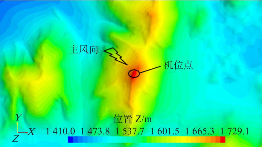
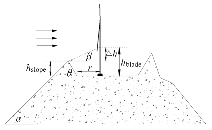
    某一机位地形施工剖面如图1所示,在机位点左侧形成了高度为hslope,坡度为θ的高边坡,同时平台基础相对原始地形有所下降,沿山体坡面流动的气流在前坡面上端部发生流动分离,对近地面风形成干扰,使得下叶尖易处于高切变湍流区。

    Figure 1.  The section of terrain at the turbine site

  • 本文选取机位实际地形作为研究对象,在机位附近采用分辨率为2 m×2 m高精度测绘地图,主要以山脉、道路为主,范围覆盖直径约2 km。外区域采用30 m×30 m低精度地图,此地图来自于地理空间数据云-DEM数字高程数据-GDEMDEM 30 m分辨率数字高程数据,两种地图是在坡度较缓的位置做的拼接,拼缝宽度80 m,拼接段进行了线性插值过渡。由于拼段两侧都是取自实际地形,拼缝相比计算域极小,而且远离风机(约1 km),地形起伏较缓,此种处理方式对模拟结果影响可以忽略不计[9]。生成的地形高程图如图2所示。

    Figure 2.  The elevation map of terrain

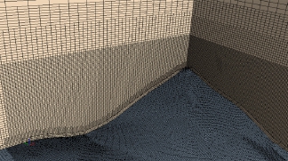
    以机位为中心,建立长方体计算域,入口距风机位置4 km,出口距风机6 km,计算域高取2 km,两侧距风机3.2 km。网格划分策略参考文献[10,11],采用六面体非结构化网格对区域进行离散,壁面首层网格高度为1 m,高度方向采用棱柱体边界层,渐变率为1.2,共5层,对机位点地形网格进行单独加密,最终网格总数约为1 200万,如图3所示。

    Figure 3.  Mesh of terrain

    底部地形边界为壁面边界,顶部和侧面为对称边界,出口为压力出口边界,入口来流风速分布采用对数率分布[12]

    ((1))
    ((2))

    式中:uτ为摩擦速度;k为Karman常数;zh为临界高度;z0为地面粗糙度;zrefuref分别为参考高度和参考风速,假定入口100 m高度风速为8 m/s,入口风速大小采用上式风廓线形式表示。

    湍流模型选用RNG k-e模型,边界层内流场采用近壁面函数处理。仿真采用稳态求解,设置最大内迭代步数1 000步,通过监控风速和残差收敛性来得获到稳定流场。

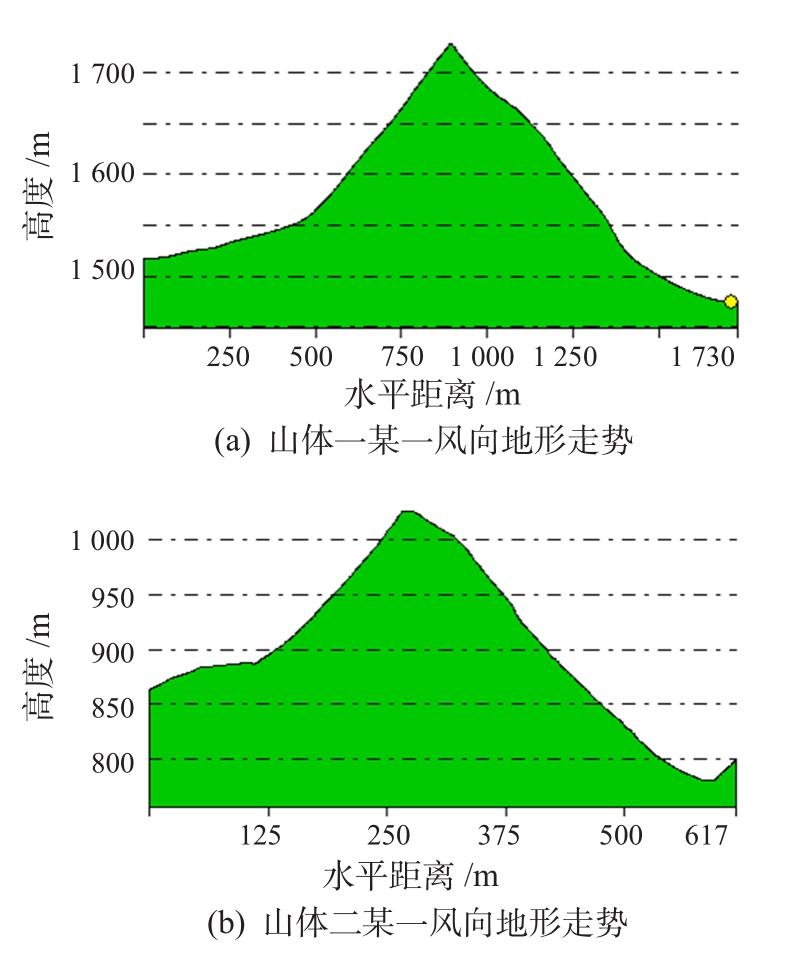
  • 工程中选择立机地形坡面坡度一般不超过45°,为了研究不同坡度风参数特征,本文选取了内蒙正镶白旗坡度24°山体一和赣州双山坡度36°山体二作为研究对象,分析复杂山区风资源特征。山体一和山体二主风向地形走势如图4所示。

    Figure 4.  The terrain trend map at the turbine site

    两山体取自实际风场地形,山体坡面延伸长度不一,以山体剖面中线为零点,根据地形特征,均匀取若干位置点作为分析对象,如表1所示。

    位置点 1 2 3 4 5
    山体一 —400 —200 0 150 300
    山体二 —200 —100 0 100 200

    Table 1.  
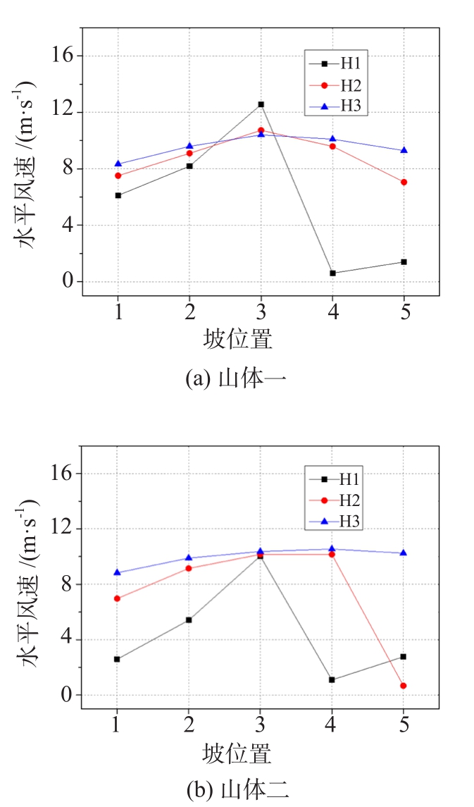
The location of the monitoring site m

    建设机位采用的机型叶轮直径为145 m,轮毂标准设计高度为90 m,风力发电机组设计等级为IEC SB级。用H1H2H3表示下叶尖高度、轮毂高度、上叶尖高度。

    来流风沿山体前坡面流动具有加速效果,在山顶位置3处达到最大,山顶处垂向风切变值较小或为负。如图5图6所示,山体后方尾流受地形影响较大,低层风速很低,湍流强度较大,因此应避免在山体主风向背风侧立机。

    Figure 5.  The horizontal wind speed at different heights of two mountains

    Figure 6.  The turbulence intensity at different heights of two mountains

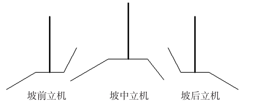
  • 机位平台建设受保护区、施工条件、载荷安全性等条件限制,立机位置可以分为坡前、坡中、坡后三种状况,其结构形式如图7所示。

    Figure 7.  Three ways of turbine construction

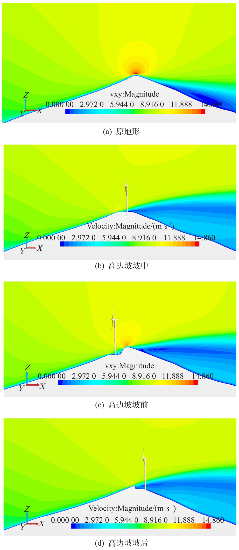
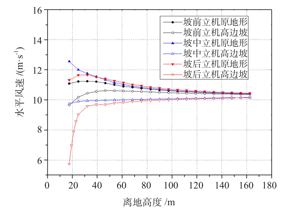
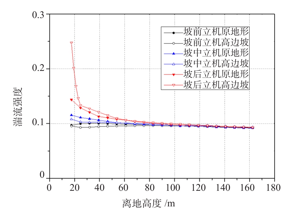
    以山体一为分析对象,本节比较了在同一来流下这三种情形风参数状况。高边坡高度为10 m,平台直径约为40 m。四种地形风速分布特征如图8所示,同一山体不同立机位置高度方向水平风速大小和湍流强度大小如图9图10所示。

    Figure 8.  The wind speed distribution of four kinds of terrain feature

    Figure 9.  The horizontal wind speed distribution at different location of turbine

    Figure 10.  The turbulence intensity at different location of turbine

    原地形在山顶处出现常见的加速效应,坡中立机和坡后立机在机位均出现大幅流动分离,并且流动分离区占据了一定的高度。只有坡前立机在机位高度方向保持较平缓速度过渡。

    根据图9图10可知,不同立机位置选择对机位盘面风速影响差别较大,坡前立机盘面水平风速分布较接近原地形,下叶尖、轮毂、上叶尖高度风速分别降低7.7%、0.6%、0.2%,坡中立机叶轮下叶尖、轮毂、上叶尖风速分别降低22.4%、6.0%、2.4%,坡后立机叶轮下叶尖、轮毂、上叶尖风速分别降低50%、6.8%、2.6%,同时,坡后立机在低高度范围风速急剧变化,切变值和湍流强度均偏高。因此,在机位平台建造时,应选择在靠近迎流方向一侧建设基础平台。

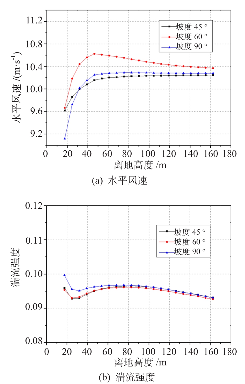
  • 本节比较了同一地形下坡前立机三组不同开挖坡度对应的风参数,机位高边坡坡度分别为45°、60°、90°,其中90°可认为垂直边坡,机位处原地形统一下挖5 m。不同坡度下机位高度方向水平风速和湍流强度如图11所示。

    Figure 11.  The wind parameters in different slopes

    根据图11可知,在坡前立机后,高边坡坡度对机位处风速影响并不显著,三种边坡方案中坡度60°最佳,坡度90°方案在低高度层风速所减弱,三者湍流强度相差不大。因此,高边坡坡度对坡前立机影响较小。

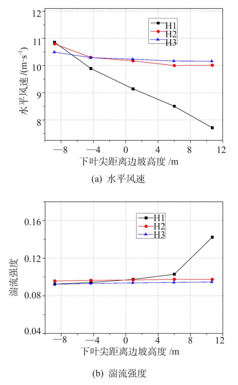
  • 山坡地形为了平台面积和基础稳定性满足要求,通常会增加机位平台下挖深度,本节在保持相同的高边坡坡度条件下,对机位平台不同下挖高度进行仿真计算,开挖深度的改变,本质上改变了机组下叶尖与边坡的距离关系,下叶尖在边坡高度之下,流动会受边坡遮挡。

    盘面下叶尖高度风速受边坡高度影响最敏感,随着下挖深度增加,下叶尖距离高边坡坡面愈近,甚至埋于坡面以下,风速降低严重,如图12所示,正值表示下叶尖在边坡之下,轮毂高度和上叶尖高度随下挖深度增加风速降低率逐渐趋于平缓。下叶尖高度对应风切变值如表2所示,此分析针对坡前立机的状况,若背坡来风,机位平台处受开挖深度影响更敏感,下叶尖遮挡会使机组下盘面风况极度恶化。

    Figure 12.  The wind parameters in different depth of platform

    下叶尖距离坡面垂直高度 —9.0 —4.0 0.0 4.0 9.0
    下叶尖风切变值 0.04 0.06 0.11 0.25 0.46

    Table 2.  The degree of wind shear at lower blade tip m

  • 通过建立三维风场模型和CFD数值模拟计算方法,研究了高边坡影响下的机位风资源特性,得出如下结论:

    1)来风沿山体坡面流动具有加速效果,在山顶处风速达到最大,而山顶高度方向风切变较小。

    2)当高边坡位于机组上风向时,机组下叶尖高度层风速变化剧烈,流体分离严重,湍流强度较高,易产生较大的风切变,对叶片安全性造成影响,因此,应该避免将风机立于高边坡坡后。而坡前立机时盘面水平风速分布较接近原地形,风切变值和地形湍流强度均符合要求。在微观选址中,应根据常年测风数据确定主风向,对风向集中的地形,建议将机位选定于山脊主风向前侧。

    4)高边坡坡度大小会影响流体贴坡流动特征,但对于坡前立机,高边坡坡度对机位处风速影响并不显著,这主要与流动分离位置点后移有关。

    5)盘面下叶尖高度风速受边坡高度影响最敏感,随着下挖深度增加,下叶尖距离高边坡坡面愈近,甚至埋于坡面以下,风速降低严重,而轮毂高度和上叶尖高度随下挖深度增加风速降低率逐渐趋于平缓。在边坡高度无法改变的情况,可以适当抬高塔筒以避免高边坡影响。

Reference (12)

Catalog

    /

    DownLoad:  Full-Size Img  PowerPoint
    Return
    Return