• Peer Review
  • Non-profit
  • Global Open Access
  • Green Channel for Rising Stars
Volume 10 Issue 1
Jan.  2023
Turn off MathJax
Article Contents

NIU Haifeng, LI Xianghui, LIANG Feng, LI Ya, ZHANG Zijian. Research and Application of Geotechnical Data Consistency in Marine Site Exploration[J]. SOUTHERN ENERGY CONSTRUCTION, 2023, 10(1): 124-132. doi: 10.16516/j.gedi.issn2095-8676.2023.01.016
Citation: NIU Haifeng, LI Xianghui, LIANG Feng, LI Ya, ZHANG Zijian. Research and Application of Geotechnical Data Consistency in Marine Site Exploration[J]. SOUTHERN ENERGY CONSTRUCTION, 2023, 10(1): 124-132. doi: 10.16516/j.gedi.issn2095-8676.2023.01.016

Research and Application of Geotechnical Data Consistency in Marine Site Exploration

doi: 10.16516/j.gedi.issn2095-8676.2023.01.016
  • Received Date: 2022-05-30
  • Rev Recd Date: 2022-07-23
  • Available Online: 2022-12-14
  • Publish Date: 2023-01-11
  •   Introduction  The current marine geological exploration, particularly the geotechnical investigation, often follows traditional experiences without a clear objective, and lacks the evaluations of soil sample disturbance and test results. Therefore, it is necessary to conduct in-depth research on marine geotechnical investigation technology.   Method  Based on the domestic and international research on marine geological exploration technology and multi-year working experience in different sea areas, we developed a new accurate marine geological exploration technology with emphasis on the principle of consistency. The geotechnical investigation part of the new method included two basic aspects: (1) comprehensive evaluation of soil sample disturbance; (2) comprehensive evaluation of consistency of soil strength test results.   Result  The three-dimensional cross-consistency analysis of geotechnical, geophysical, and geological models has established an accurate geological exploration system. Several examples of marine engineering projects showed that the new technology can screen good acquisition methods and data through comprehensive evaluation of clay soil sample disturbance, and conduct consistency analysis of various data by combining the laboratory geotechnical tests with in-situ tests and the routine geotechnical tests with advanced geotechnical tests to obtain richer and more continuous data at the borehole. Compared with the traditional single geotechnical test, our new technology demonstrated the improved reliability and accuracy of the data, and the missing data between the sampling points are compensated.   Conclusion  The proposed new method can reinforce the application of geological exploration data, reduce investigation costs, and provide more geotechnical parameters that are more reliable for marine engineering projects including offshore wind power.
  • [1] RANDOLPH M, GOURVENEC S. Offshore geotechnical engineering [M]. London: Spon Press, 2011: 520-520. DOI:10.1201/9781315272474.
    [2] Offshore Site Investigation and Geotechnics Group (OSIG) of the Society for Underwater Technology (SUT). Guidance notes for planning and execution of geophysical and geotechnical ground investigations for offshore renewable energy developments [R]. London: Society for Underwater Technology (SUT), 2014.
    [3] KOLK H J, WEGERIF J. Offshore site investigations: new frontiers [C]// Anon. International Symposium on Frontiers in Offshore Geotechnics ISFOG, Perth, Western Australia, 19-21 September 2005. Perth: [s. n.], 2005.
    [4] Norwegian Petroleum Industry. Marine soil investigations: NORSOK G-001 [S]. Norway: Standards Norway, 2004.
    [5] ASTM International. ASTM standards on disc volume 04.08: soil and rock (I): D 420 - D 5611 [M]. West Conshohocken: ASTM International, 2005.
    [6] ASTM International. ASTM standards on disc volume 04.09: soil and rock (II): D 5714 – Latest [M]. West Conshohocken: ASTM International, 2005.
    [7] European Committee for Standardization. Eurocode 7: geotechnical design-part 1: general rules: BS EN 1997-1: 2004 [S]. UK: CEN European Committee for Standardization, 2004.
    [8] 中华人民共和国建设部. 岩土工程勘察规范: GB 50021—2001 [S]. 北京: 中国建筑工业出版社, 2009.
    [9] ROBERTSON P K. Soil classification using the cone penetration test [J]. Canadian Geotechnical Journal, 1990, 27(1): 151-158.
    [10] ROBERTSON P K. Interpretation of cone penetration tests-a unified approach [J]. Canadian Geotechnical Journal, 2009, 46(11): 1337-1355.
    [11] LADD C C, DEGROOT D J. Recommended practice for soft ground site characterization [C]// Anon. Soil and Rock America 2003: 12th Panamerican Conference on Soil Mechanics and Geotechnical Engineering, Cambridge, 2003. Cambridge: [s. n.], 2003: 3-57.
    [12] 李亚, 张超. 土样扰动对土工参数选取的影响及导管架桩基承载力计算 [C]// 中国石油学会. 中国石油学会石油工程专业委员会海洋工程工作部2013年学术会议, 北京, 2013. 北京: 中国石油学会, 2013: 30-37.

    LI Y, ZHANG C. Impact of soil disturbance to geotechnical parameters and pile capacity of jacket platforms [C]// Chinese Petroleum Society. 2013 Academic Conference of Offshore Engineering Department, Petroleum Engineering Committee, Chinese Petroleum Society, Beijing, China, 2013. Beijing: Chinese Petroleum Society, 2013: 30-37.
    [13] Anon. Petroleum and natural gas industries-specific requirements for offshore structures-part 8: marine soil investigations: ISO 19901-8: 2014 [S]. Switzerland: ISO, 2014.
    [14] LUNNE T, BERRE T, ANDERSEN K H, et al. Effects of sample disturbance and consolidation procedures on measured shear strength of soft marine Norwegian clays [J]. Canadian Geotechnical Journal, 2006, 43(7): 726-750. DOI:  10.1139/t06-040.
    [15] LADD C C, FOOTT R. Closure to "new design procedure for stability of soft clays" [J]. Journal of the Geotechnical Engineering Division, 1975, 101(11): 1169-1172. DOI:  10.1061/AJGEB6.0010721.
    [16] SENNESET K, JANBU N, SVANO G. Strength and deformation parameters from cone penetration tests [C]//ESOPT II. Proceedings of the Second European Symposium on Penetration Testing, Amsterdam, 24-27 May 1982. Amsterdam: Balkema Pub, 1982: 863-870.
    [17] WROTH C P. Penetration tests-a more rigorous approach to interpretation: proc 1st international symposium on penetration testing, ISOPT-1, Orlando, 20-24 March 1988 V1, P303–311. Rotterdam: A A Balkema, 1988 [J]. International Journal of Rock Mechanics and Mining Sciences & Geomechanics Abstracts, 1990, 27(2): A92. DOI:  10.1016/0148-9062(90)95090-N.
    [18] MAYNE P W, BACHUS. Profiling OCR in clays by piezocone soundings: Mayne, P W; Bachus, R C proc 1st international symposium on penetration testing, ISOPT-1, Orlando, 20-24 March 1988 V2, P857–864. Publ Rotterdam: A A Balkema, 1988 [J]. International Journal of Rock Mechanics and Mining Sciences & Geomechanics Abstracts, 1990, 27(6): 353. DOI:  10.1016/0148-9062(90)91261-5.
    [19] JAMIOKOWSKI M B, LADD C C, GERMAINE J T, et al. New developments in field and laboratory testing of soil [C]//ISSMGE. 11th International Conference on Soil Mechanics and Foundation Engineering, San Francisco, 12-16 August 1985. Rotterdam: AA Balkema, 1985: 57-153.
  • 通讯作者: 陈斌, bchen63@163.com
    • 1. 

      沈阳化工大学材料科学与工程学院 沈阳 110142

    1. 本站搜索
    2. 百度学术搜索
    3. 万方数据库搜索
    4. CNKI搜索

Figures(11)  / Tables(1)

Article Metrics

Article views(122) PDF downloads(45) Cited by()

Related

Research and Application of Geotechnical Data Consistency in Marine Site Exploration

doi: 10.16516/j.gedi.issn2095-8676.2023.01.016

Abstract:   Introduction  The current marine geological exploration, particularly the geotechnical investigation, often follows traditional experiences without a clear objective, and lacks the evaluations of soil sample disturbance and test results. Therefore, it is necessary to conduct in-depth research on marine geotechnical investigation technology.   Method  Based on the domestic and international research on marine geological exploration technology and multi-year working experience in different sea areas, we developed a new accurate marine geological exploration technology with emphasis on the principle of consistency. The geotechnical investigation part of the new method included two basic aspects: (1) comprehensive evaluation of soil sample disturbance; (2) comprehensive evaluation of consistency of soil strength test results.   Result  The three-dimensional cross-consistency analysis of geotechnical, geophysical, and geological models has established an accurate geological exploration system. Several examples of marine engineering projects showed that the new technology can screen good acquisition methods and data through comprehensive evaluation of clay soil sample disturbance, and conduct consistency analysis of various data by combining the laboratory geotechnical tests with in-situ tests and the routine geotechnical tests with advanced geotechnical tests to obtain richer and more continuous data at the borehole. Compared with the traditional single geotechnical test, our new technology demonstrated the improved reliability and accuracy of the data, and the missing data between the sampling points are compensated.   Conclusion  The proposed new method can reinforce the application of geological exploration data, reduce investigation costs, and provide more geotechnical parameters that are more reliable for marine engineering projects including offshore wind power.

NIU Haifeng, LI Xianghui, LIANG Feng, LI Ya, ZHANG Zijian. Research and Application of Geotechnical Data Consistency in Marine Site Exploration[J]. SOUTHERN ENERGY CONSTRUCTION, 2023, 10(1): 124-132. doi: 10.16516/j.gedi.issn2095-8676.2023.01.016
Citation: NIU Haifeng, LI Xianghui, LIANG Feng, LI Ya, ZHANG Zijian. Research and Application of Geotechnical Data Consistency in Marine Site Exploration[J]. SOUTHERN ENERGY CONSTRUCTION, 2023, 10(1): 124-132. doi: 10.16516/j.gedi.issn2095-8676.2023.01.016
    • 海洋地勘中的岩土勘测是指通过取样测试或者原位测试的方法,获取指定点位指定深度处海床土体的物理力学信息[1-4]。其中,海床土体的力学强度特征,特别是静载条件下黏性土的不扰动不固结不排水强度Su和砂性土的内摩擦角φ,是海洋工程最直接、最基本的勘察参数,也是最容易受到外界影响而出现较大偏差的参数[5-7]

      当前,我国海洋岩土勘测普遍采用以钻孔取样测试为主、以原位测试为辅的方法[8]。其中,静力触探(CPT)是最为常用的海洋岩土原位测试工具[9-10]。在取样测试方法中,由于较高围压的存在,海床土样的扰动是不可避免的,土样扰动可显著改变土样原本的强度和变形特征,是影响海洋地勘质量的关键因素[11]。当前我国海洋地勘多采用陆地式钻机+自升式平台这种装备组合获取土样,容易导致土样的较大扰动,在后续的土样保存、运输及操作环节,也缺乏针对性的保护措施。上述环节产生的土样扰动将直接影响后续的土工测试。此外,土工测试自身也容易产生偏差。考虑到海床物理力学特征的标准值/真实值难以确定,如果勘测各环节技术手段单一,例如土体的Su强度仅通过常规三轴试验量测,仅仅依赖单一测试,则难以对勘测结果的可靠性做出评判。另一方面,为有效避免土样扰动等因素对土体测试的干扰,以CPT为代表的原位测试方法在海洋地勘中得到广泛应用。然而,当前常用的CPT数据解释方法(即Nkt系数法)在本质上仍需回归到高质量的钻孔取样测试结果进行标定[12]。因此,当前的原位测试技术还不是一种完全独立的土体强度勘测方法,不能用来独立校核钻孔取样的勘测结果。综上所述,由于缺乏土样扰动评估,单一式的钻孔取样土工测试无法对测试结果去芜存菁,同时,原位测试的CPT技术虽然避免了土样扰动,但经验参数如不校正很难得到精准数据。因此,现有地勘技术存在较大的经验性和盲目性,无法达到精准地勘要求。

      基于以上认知,本文介绍一种基于一致性原则的海洋岩土勘测新方法,有效地整合了钻孔取样不连续单点数据和原位测试连续曲线数据。新技术主要包括两个基本环节:(1)钻孔取样土样扰动综合评估;(2)钻孔取样和原位测试土体强度测试结果的一致性综合评估。

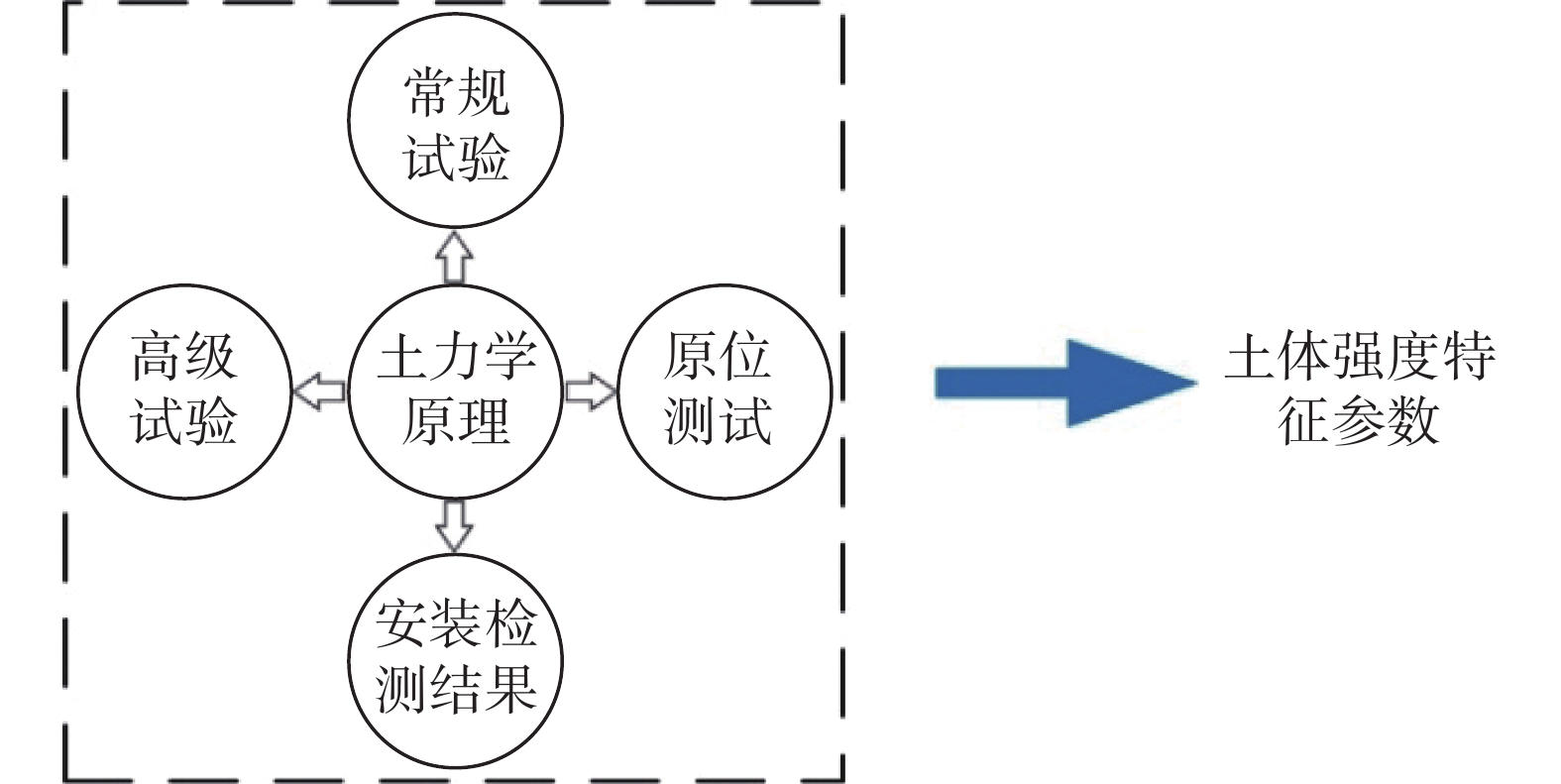
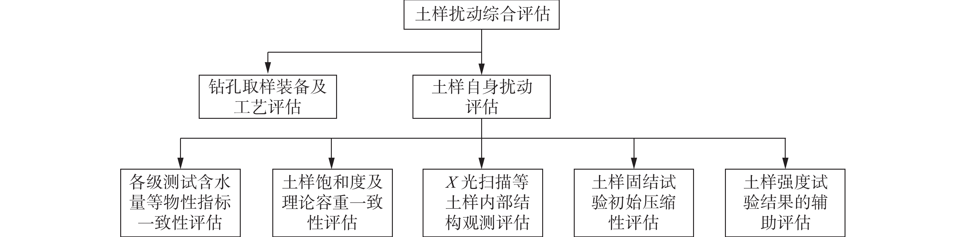
    • 海洋岩土勘测技术首先应该通过各种观测方法,对获得的土样进行扰动评估。需要澄清的是,土样扰动评估的目的是评估土样的扰动状况并筛选较好的土样为后续土工试验做准备,而不是弱化合理的钻孔取样装备及取样工艺在海洋地勘中的关键作用。土样扰动评估的主要内容如图1所示。其中,本文主要关注获取土样后,土样自身的扰动评估。

      Figure 1.  Main contents in comprehensive assessment of soil disturbance

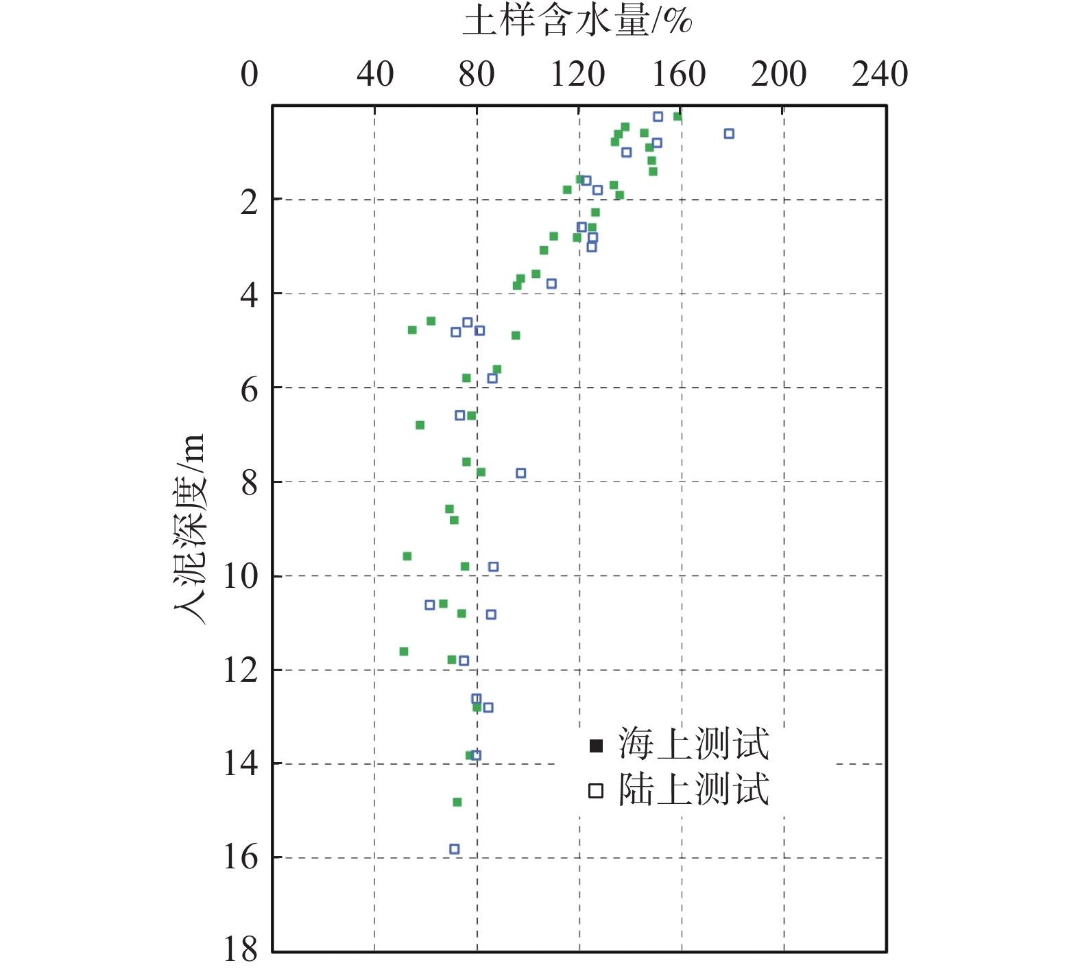
    • 通常情况下,如果海上船载土工实验室能力允许,在海上获取土样后,土样应尽快进行土工测试,这尤其适用于相对简易的土样物性测试。其余土样则封存起来,以待后期在陆上实验室进行更为复杂的土工试验。通过海上土样含水量试验结果与陆上试验结果的一致性比较,可以显示封存、运输及其他环节是否对土样产生进一步的扰动影响。做为示例,图2显示了封存、运输及后续环节较好时,海上试验与陆上试验得到的土样含水量有较好的一致性。

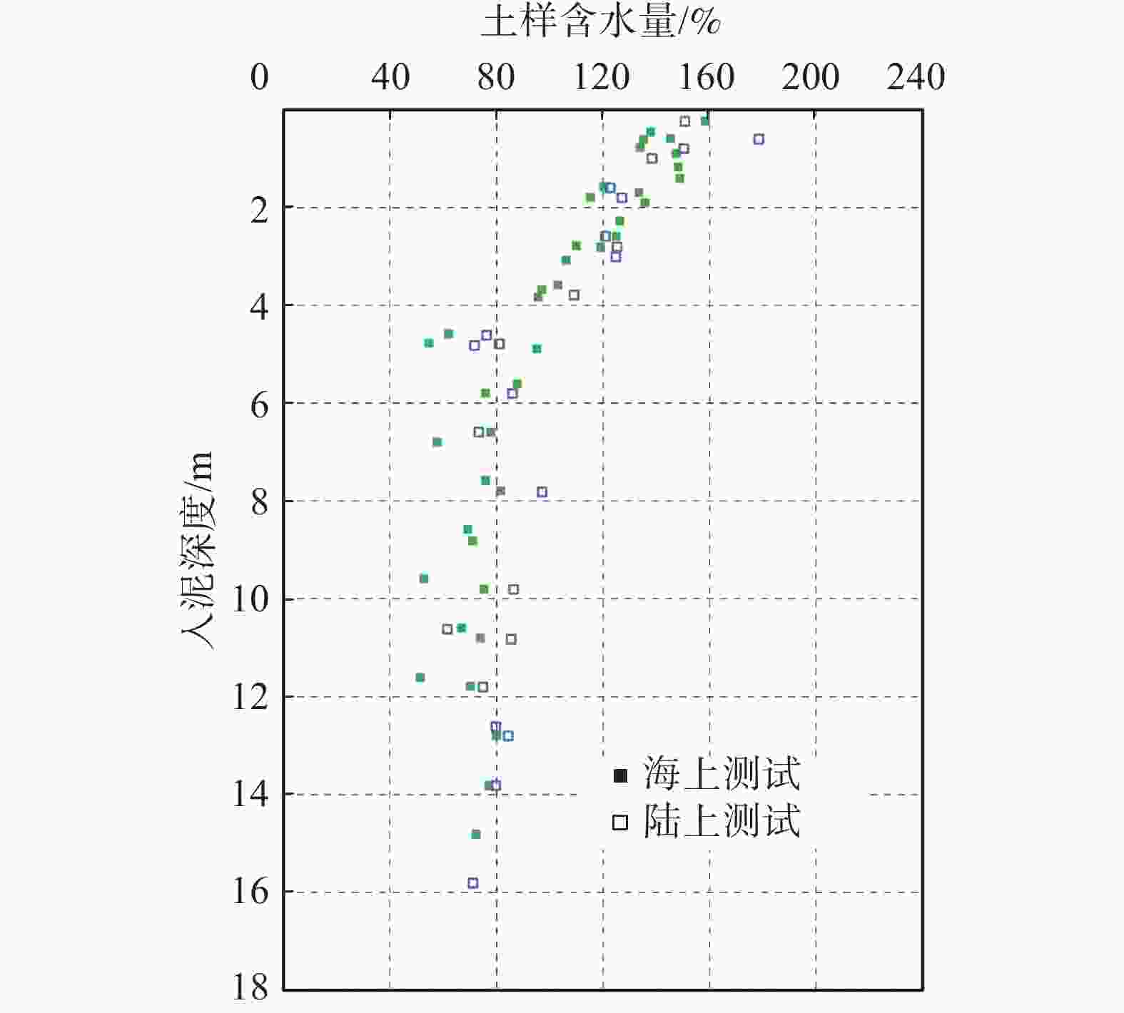
      Figure 2.  Comparison of consistency in moisture content between offshore and onshore tests

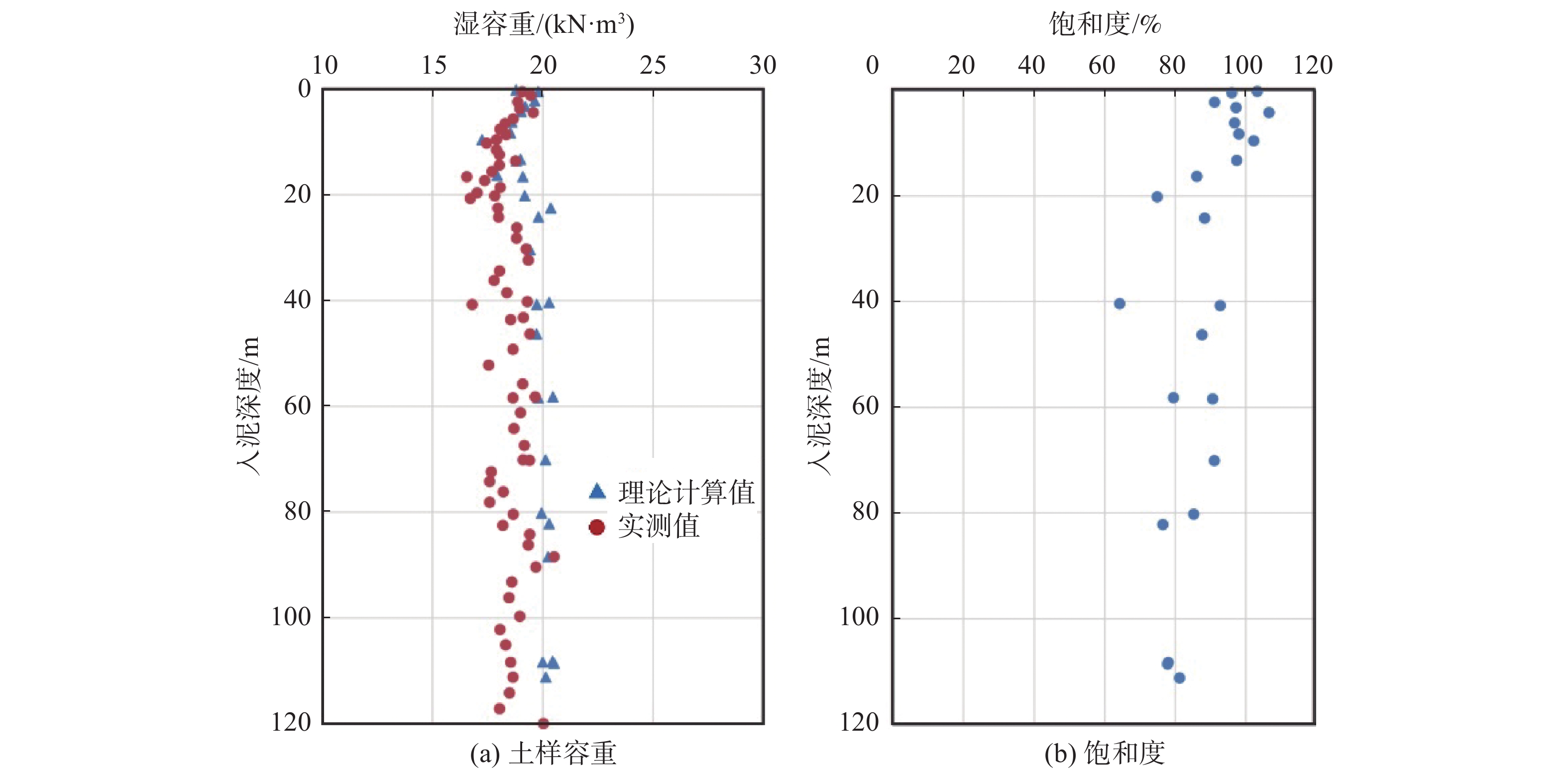
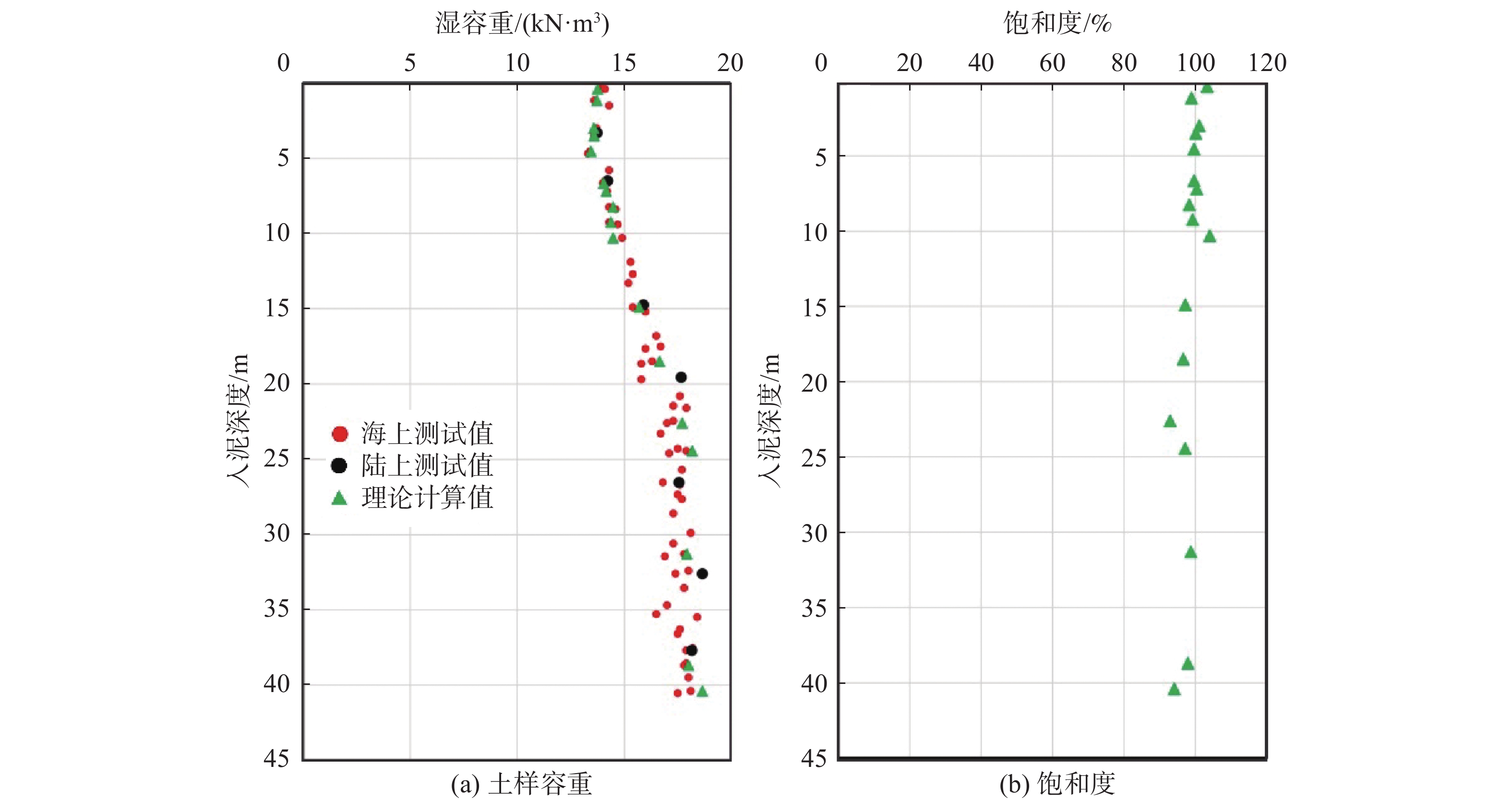
    • 海洋土样的饱和度(Sr)可以由公式(1)计算得到。海洋土样的饱和度在理论上应当是100%。但土体受到扰动导致水分丧失,特别是当围压释放,土样发生明显膨胀后,测试获得的土体含水量与理论值将有一定差异。依据饱和度判断土体膨胀性的常用准则为:(1)当Sr≥95%时,土样没有或者有轻微膨胀性;(2)当90%≤Sr<95%时,土样具有一定的膨胀性;(3)当85%≤Sr<90%时,土样具有较大的膨胀性;(4)当Sr<85%时,土样具有强烈膨胀性。土样饱和度的评价结果需要包含在地勘报告中。后续土工测试须尽量避免使用具有较大和强烈膨胀性(即c类和d类)的土样。

      $$ S_\mathrm{r}=\dfrac{{\gamma }_{{\rm{t}}}-\left[{\gamma }_{{\rm{t}}}/\left(1+w\right)\right]}{{\gamma }_{{\rm{w}}}\left[1-\dfrac{{\gamma }_{{\rm{t}}}}{{\gamma }_{{\rm{w}}}{\cdot G}_{{\rm{s}}}\cdot \left(1+w\right)}\right]} $$ (1)

      式中:

      w ——土体天然含水量(%);

      Gs——土颗粒比重;

      γw ——水的容重(g/cm3)。

      依据饱和度为100%的假定,通过海洋土样的理论容重(γt)与实测容重的一致性的比较,也可以凸显土样因围压释放而导致的土体水分丧失状况。海洋土样的理论容重(γt)可由公式(2)计算得到,其用到的参数同公式(1)。

      $$ {\gamma }_{{\rm{t}}}={\gamma }_{{\rm{w}}}\cdot \left[\dfrac{{G}_{{\rm{s}}}\left(1+w\right)}{1+{w\cdot G}_{{\rm{s}}}}\right] $$ (2)

      作为示例,图3显示某一海洋地勘项目,由于土样受围压释放影响较小时,土样饱和度与理论值(100%)较为一致(图3(a)),同时,计算得到的土样理论容重与实测值吻合度也较高(图3(b))。

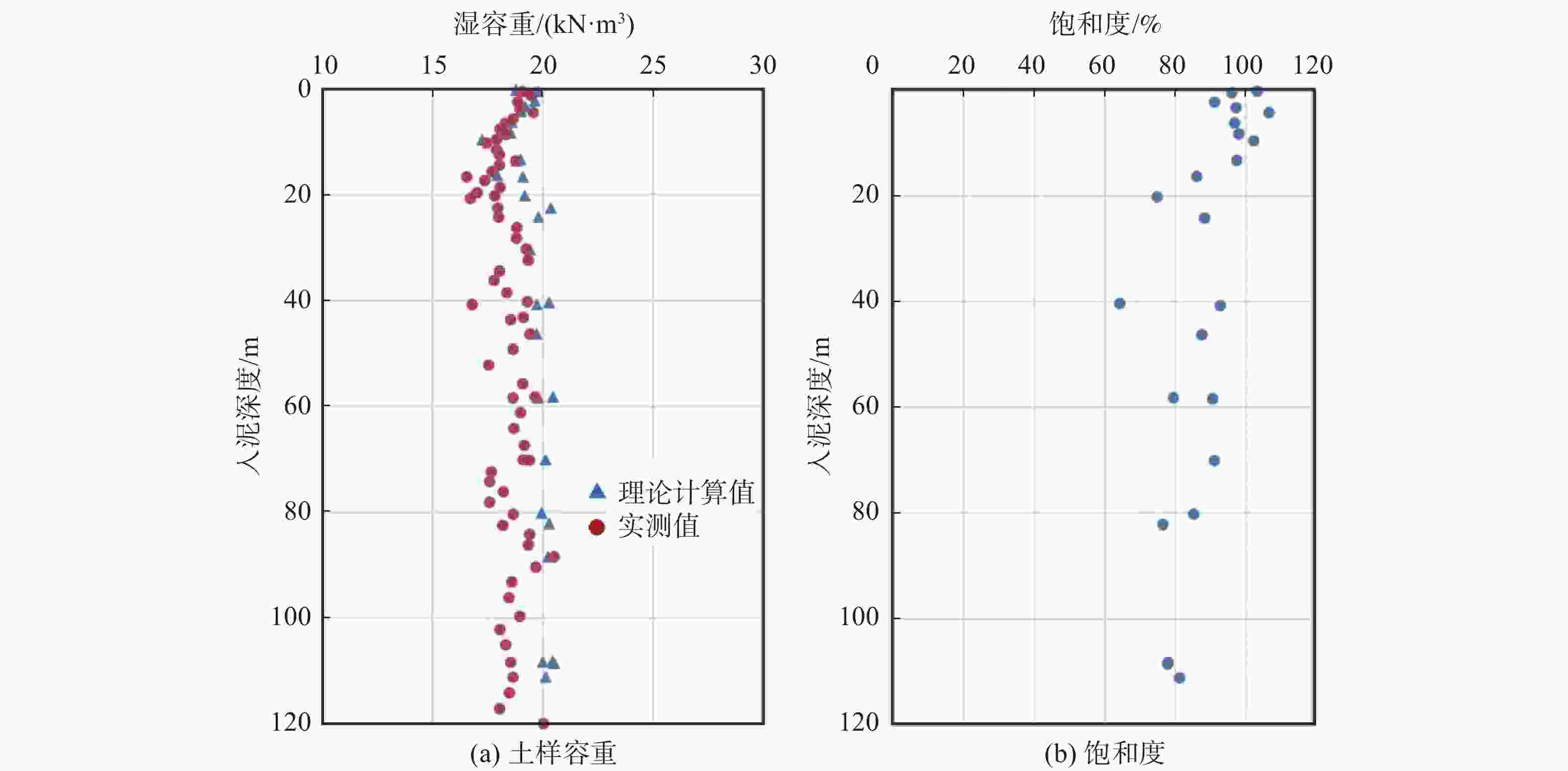
      Figure 3.  Comparison of consistency in bulk density and saturation of soil samples under great effect of confining pressure release

      相反,图4显示的则是在另外一个海洋地勘项目中,由于海床面20 m埋深以下的地层含有较多浅层气,围压释放对土体的影响较大,导致土样的饱和度显著低于其理论值(100%),同时,计算得到的土样理论容重与土样的实测容重有明显偏离。当这种情况出现时,后续的土工测试及数据解释需要慎重处理。

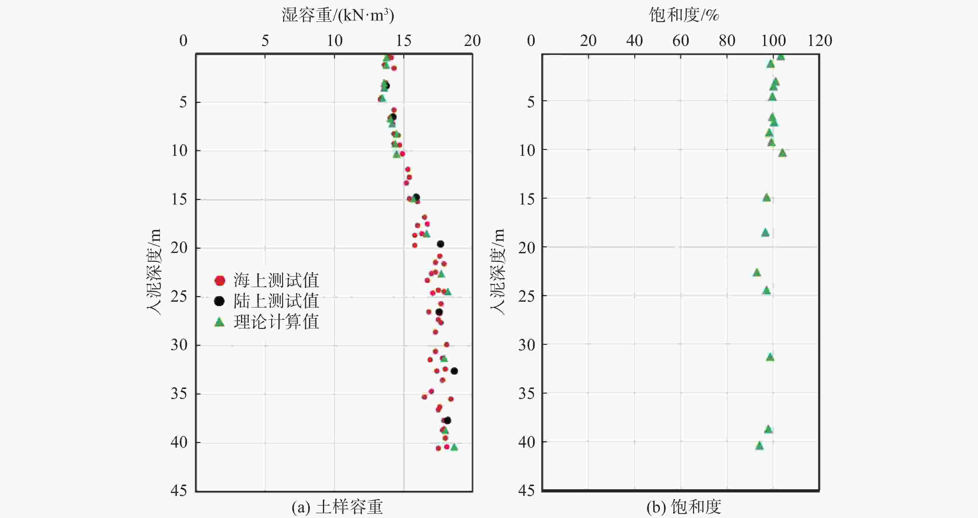
      Figure 4.  Comparison of consistency in bulk density and saturation of soil samples under small effect of confining pressure release

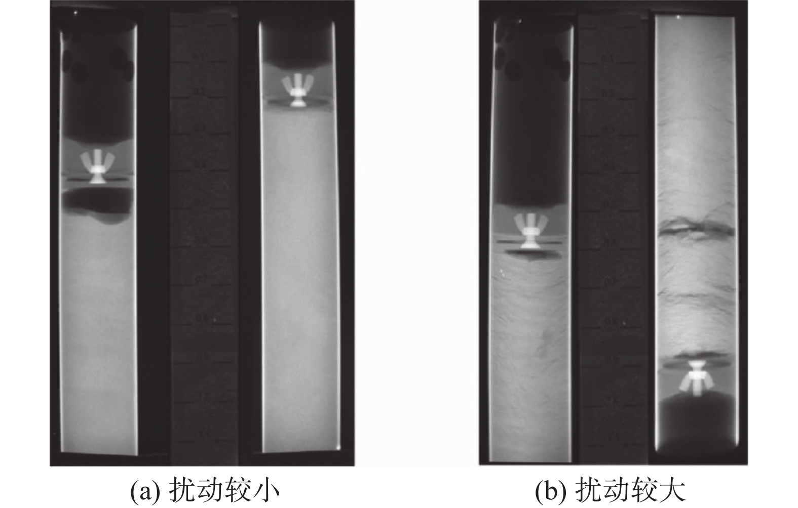
    • 通过X光衍射扫描,可显示土样内部的完整性、裂隙分布以及纹路的均匀性等结构细节,作为土样是否受到过度扰动的判断依据。图5对比了扰动较大及扰动较小土样的X光扫描图像。X光衍射图像也可以显示取样器的几何尺寸(包括直径、壁厚、长度等)对取样质量的影响。在为后续的土工试验特别是为土样扰动比较敏感的高级土工试验做准备时,应该在X光扫描图像的基础上,截取扰动较小的土样部位。

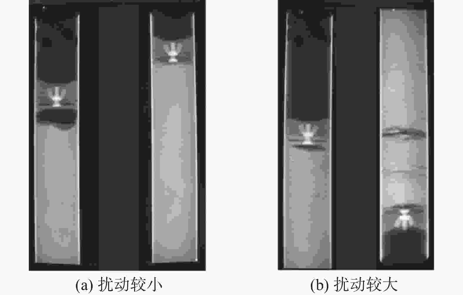
      Figure 5.  Comparison of X-Ray images of soil samples under small disturbance and great disturbance

    • 在海洋地勘过程中,由于围压释放,获取的土样会发生体积改变。在土样固结试验中,通过施加竖向荷载恢复土体原位应力状态,量测土样在相应过程中的压缩量,并结合土体的超固结比(OCR),结合表1[13-14]对土体的扰动程度进行评估。在该表中,σv0为土体的原位竖向有效荷载;Δe为固结试验施加荷载σv0后土样的孔隙比变化值;而e0为土样的初始(原位)孔隙比。上述土样扰动评价结果应包含在地勘报告中。后续的土工试验特别是对土样扰动比较敏感的高级土工试验,应选择扰动质量为I级及II级的土样。

      土体OCR范围施加荷载σv0后量测得到的Δe/e0
      1~2<0.040.04~0.07007~0.14>0.14
      2~4<0.040.03~0.050.05~0.10>0.10
      基于扰动程度的
      土样质量评估
      I(优良)II(中)III(差)IV(很差)

      Table 1.  Evaluation and classification of soil sample disturbance based on consolidation test

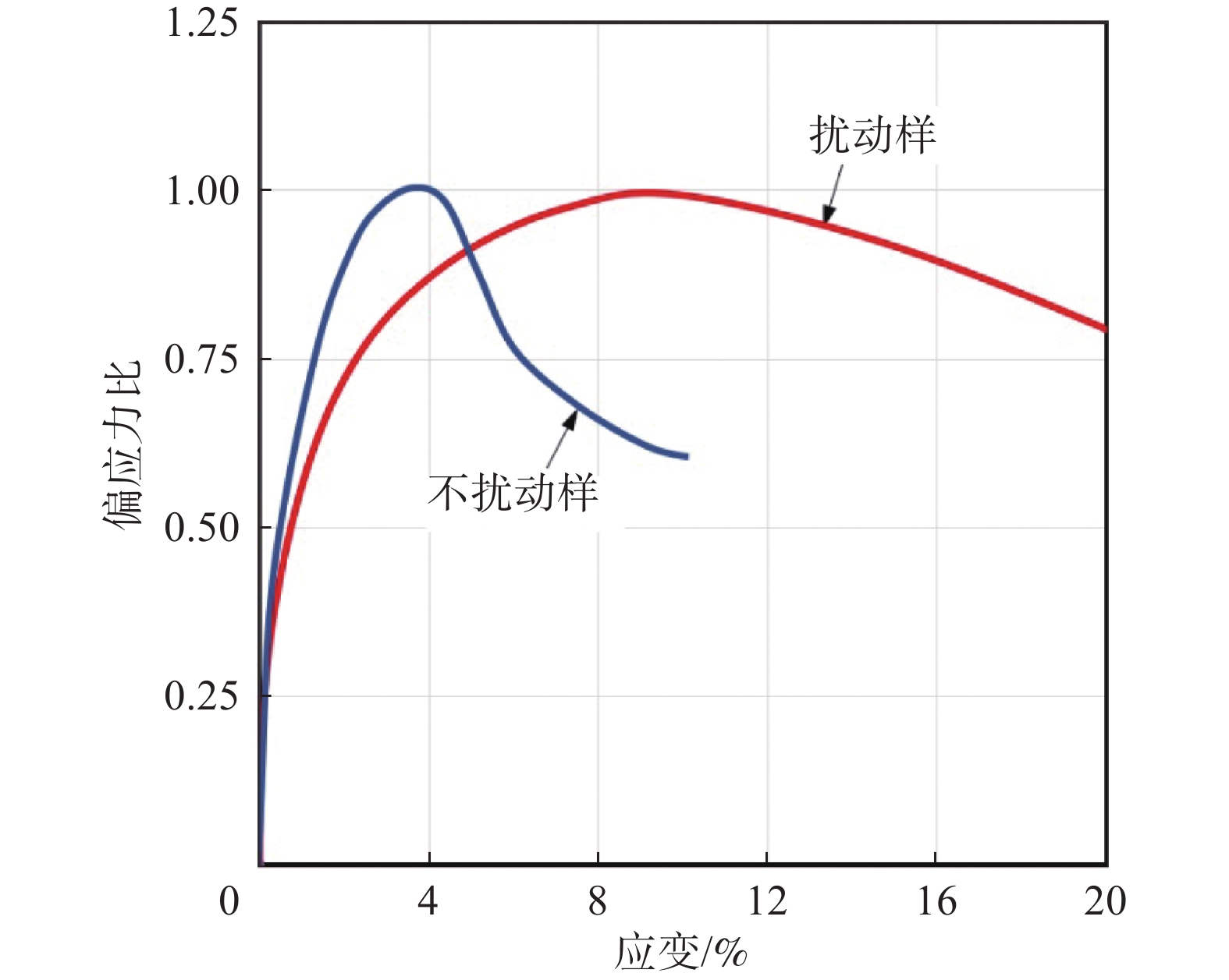
    • 海洋地勘中,不固结不排水三轴试验(即UU试验)是测量粘土强度Su的常用方法。与固结曲线相似,当使用扰动较小的粘土样时,UU试验得到的应力应变曲线通常具有明显的结构性或者“脆性”,即在峰值过后,残余强度迅速减小;而扰动较大的粘土样的曲线具有较为明显的延展性或者“塑性”。图6比较了不同扰动程度粘土样的UU应力应变曲线。此外,对于扰动较大的粘土样,其变形参数e50也往往较大。e50是UU应力应变曲线中,当偏应力比为0.5时所对应的应变值,是多个国际海洋工程规范所要求的土体变形特征参数。因此,在确定粘土样Su强度和e50特征参数时,应充分考虑UU曲线所体现的土体扰动特征。

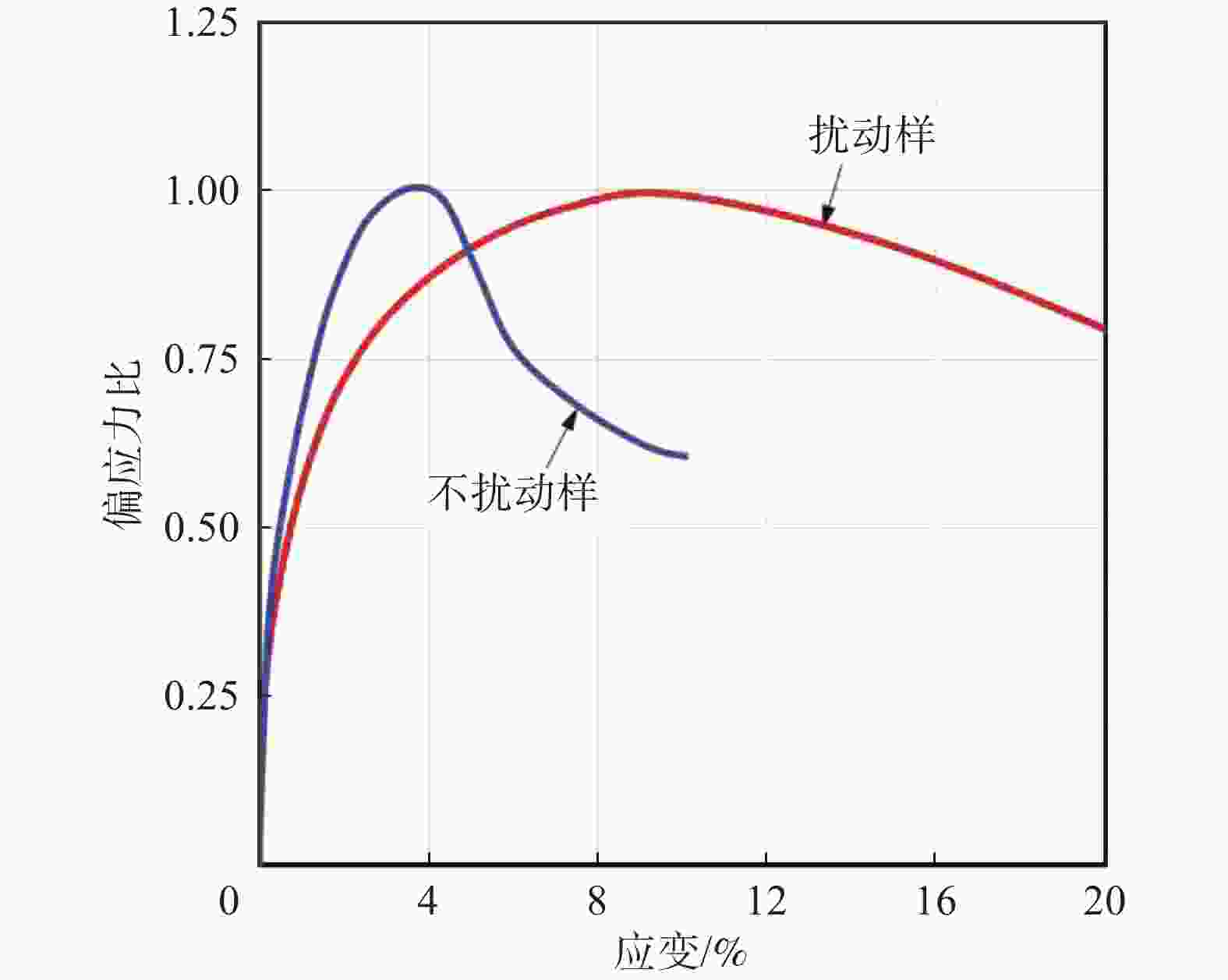
      Figure 6.  Comparison of UU curves of soil samples under different disturbance

      此外,通常情况下海洋粘土的灵敏度应该大于3。但当粘土样受到较大扰动时,其不扰动强度Su会显著降低,而土体重塑强度Sur受到的影响较小,作为二者的比值,所得到的土样灵敏度就会显著降低。当室内试验得到的粘土样灵敏度过低,就说明其土样扰动较大,相应土工试验得到的土样不扰动强度Su的可靠性就值得怀疑。

    • 如前文所述,在各种海洋地勘参数中,土体的力学强度特征,特别是静载条件下粘性土的不扰动不固结不排水强度Su和砂性土的内摩擦角φ,是海洋开发建设最直接、最基本的工程参数,也是受环境因素影响最大因而最容易出现测量偏差的地勘参数。

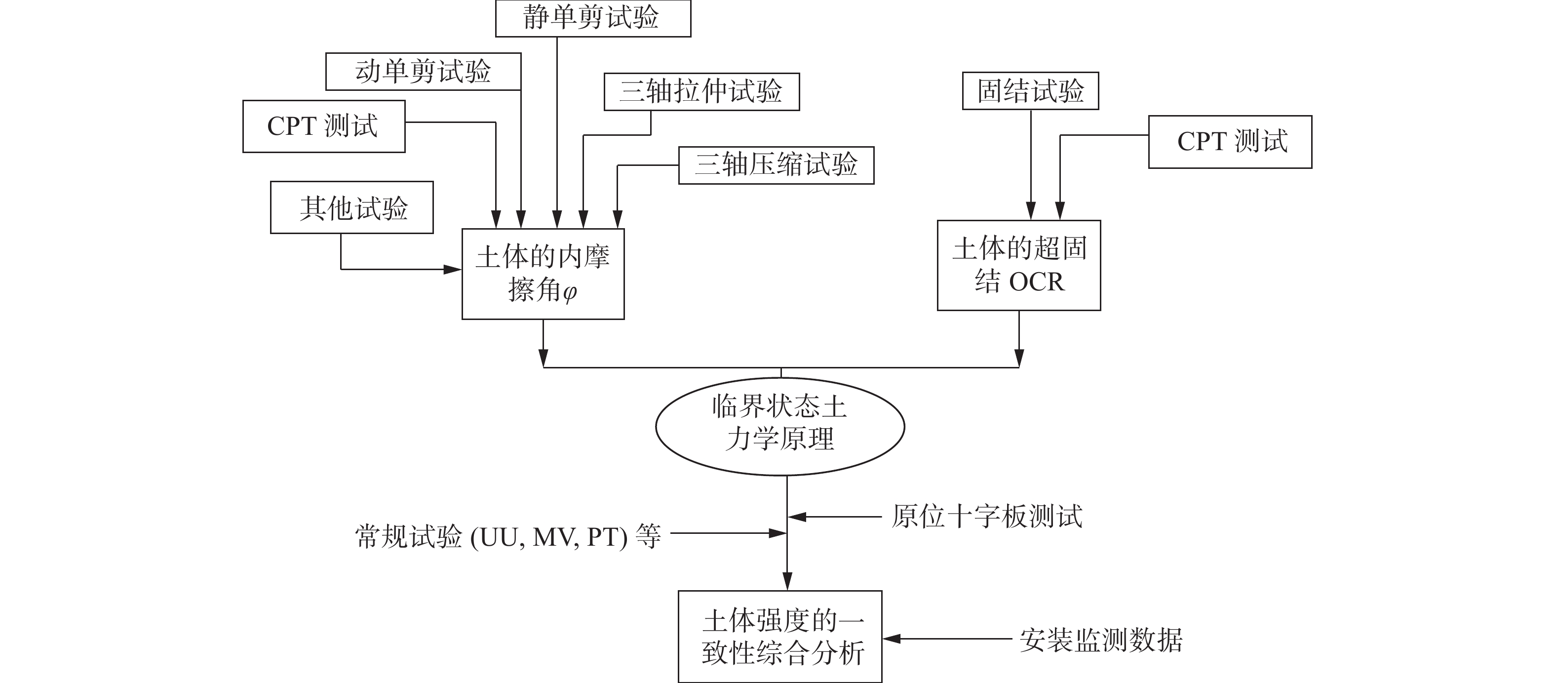
      本文所阐述的土体强度测试的一致性综合分析技术如图7所示,把室内土工试验和原位测试相结合,常规土工试验和高级土工试验相结合,在临界状态土力学理论的框架下,特别是基于SHANSEP土工测试成果[15]和基于小孔扩展理论的自洽式的孔压静力触探测试的解释[16-18],根据不同土工参数之间的内在联系,实现土体各种测量值的相互标定,在内在一致性的基础上,最终确定土体的强度特征参数。土样强度一致性综合测试分析的具体实施流程如图8所示,解释如下:

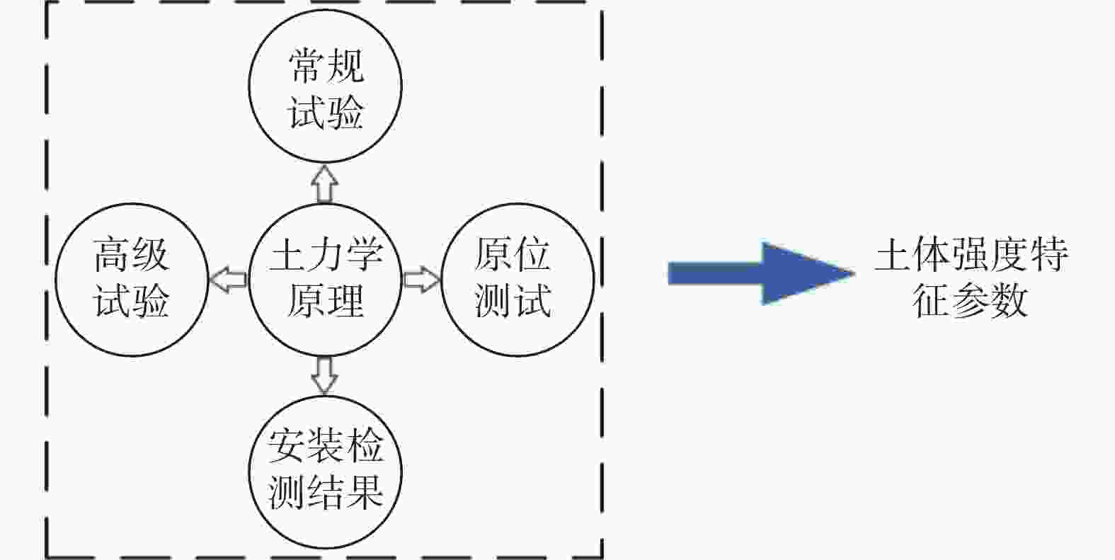
      Figure 7.  Mind map of comprehensive test and analysis of soil strength consistency

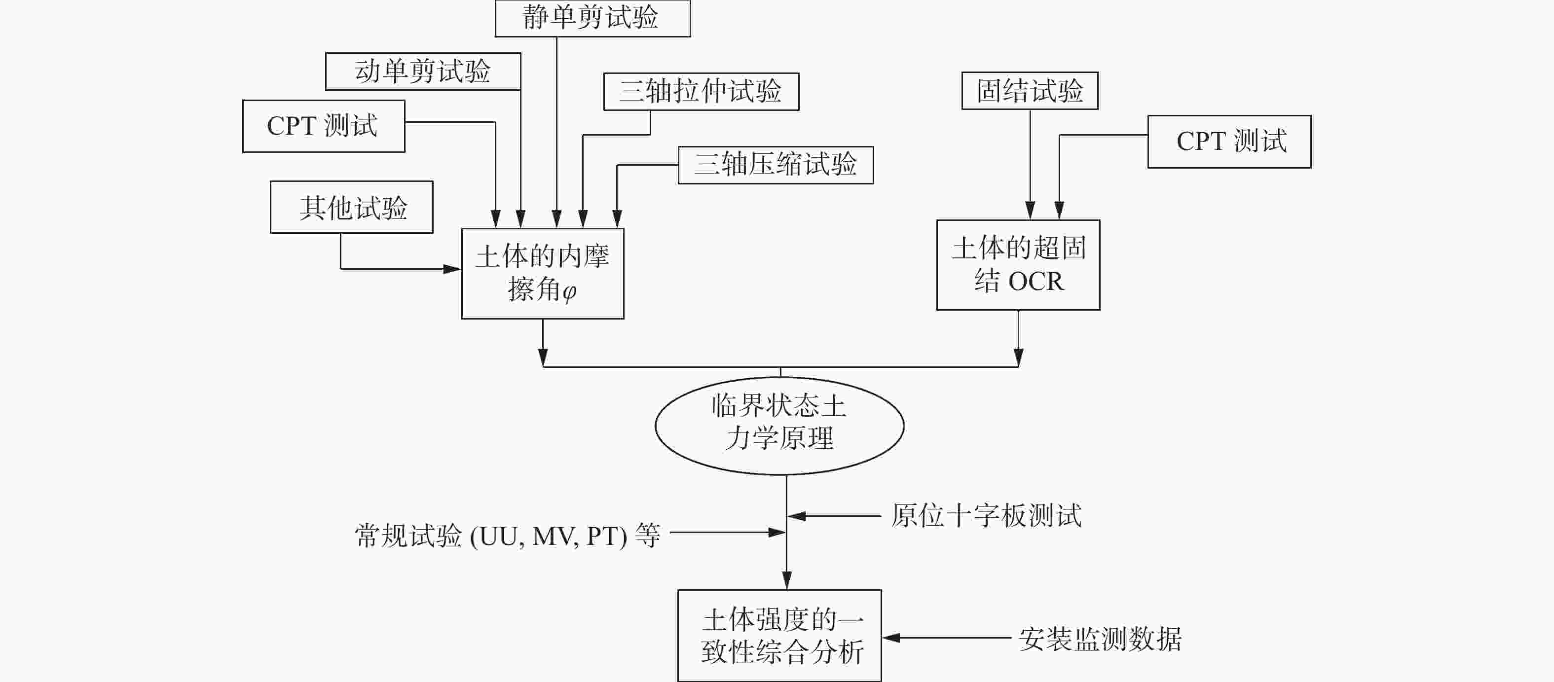
      Figure 8.  Flowchart of comprehensive test and analysis of soil strength consistency

    • 土体是一种摩擦介质。在定义土体的各种强度参数中,内摩擦角(φ)是最为基本的强度参数。土体的内摩擦角可通过单剪试验、三轴试验等强度试验获取。在这些试验中,土样内摩擦角是通过p-q平面内应力路径的最大斜率确定。

      对于易扰动的黏性土,土体内摩擦角也可在小孔扩张理论和临界状态土力学理论的基础上,从CPT测试数据出发,通过公式(3)的迭代计算获得[6]

      $$ {N}_{{\rm{q}}}={{\rm{tan}}}^{2}\left(45°+\frac{1}{2}\varphi \right)\cdot {\rm{exp}}\left[{\text{π}} \cdot {\rm{tan}}\varphi \right] $$
      $$ {N}_{{\rm{m}}}=\dfrac{{N}_{{\rm{q}}}-1}{1+{N}_{{\rm{u}}}\cdot {B}_{{\rm{q}}}}=\dfrac{{q}_{{\rm{t}}}-{\sigma }_{{\rm{vo}}}}{{{\sigma }'}_{\text{vo}}} $$ (3)
      $$ {N}_{{\rm{u}}}=6\cdot {\rm{tan}}\varphi \cdot \left(1+{\rm{tan}}\varphi \right) $$

      式中:

      Nq ——端承因子;

      Nm ——归一化锥尖阻力因子;

      Nu ——孔隙水承压因子;

      $ {\mathrm{\sigma }}_{\mathrm{v}0}、\sigma {'_{{\rm{vo}}}} $ ——土体的竖向上覆总压力和竖向上覆有效压力(kPa);

      其他参数均为CPT的直接测试值及其衍生值。

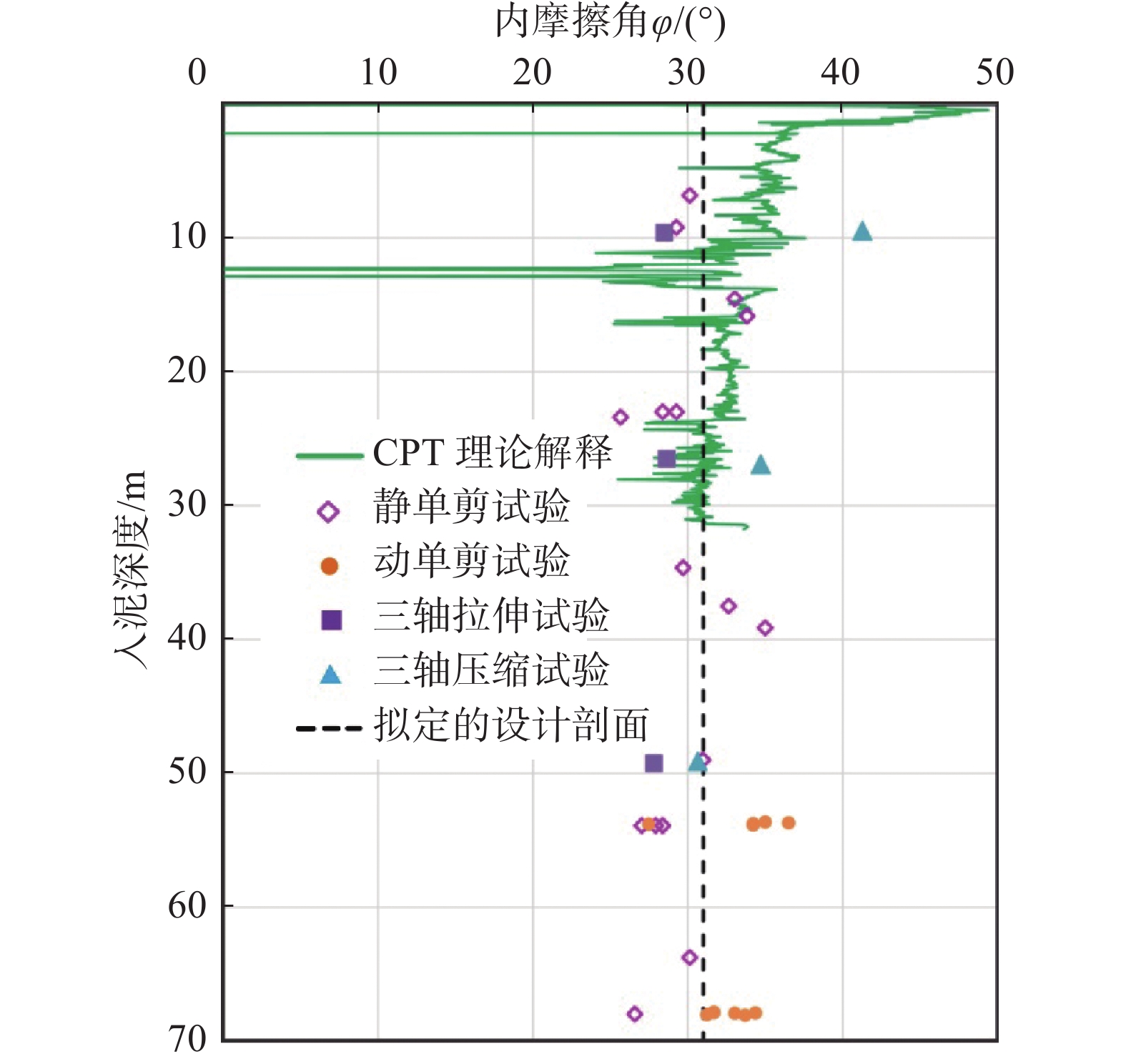
      图9显示在某一海洋地勘项目中,各种独立的土工试验及CPT原位测试得到的土体内摩擦角的分布状态,由于一致性较好,也保障了最终获得的土体内摩擦角的可靠性。

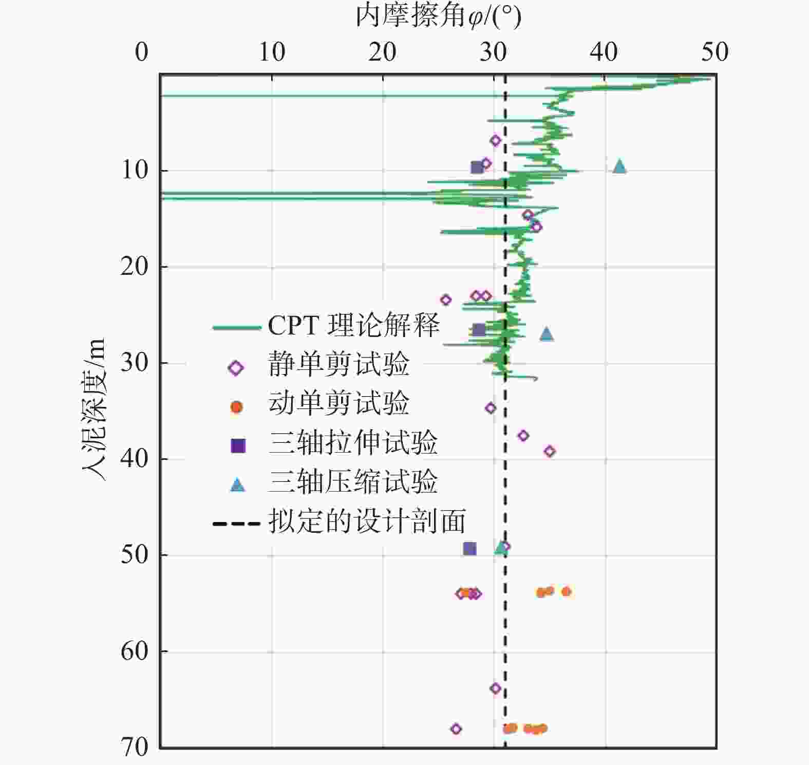
      Figure 9.  Consistency evaluation of friction angle in soil obtained from various tests and in-situ test

    • 土体的固结度OCR用于表征土体的应力历史,是定义土体的初始屈服面并决定土体表征强度的关键初始状态参数。如图8所示,土体的固结比OCR可通过固结试验直接测量和CPT原位测试分析计算两种独立的方法获得。其中,对于固结试验,可采用公式$ {\rm{OCR}} = \sigma {'_{{\rm{pc}}}}{\rm{/}}\sigma {'_{{\rm{v0}}}} $获得土体的OCR。其中,σvo是土样在埋深处所承受的上覆有效压力,由有效容重γ'随深度积分得到;σpc是土体的先期固结压力,可由固结试验的固结曲线确定。

      此外,土体的OCR也可基于小孔扩张理论基于公式(4)[18]从CPT测试数据计算得到:

      $$ \mathrm{O}\mathrm{C}\mathrm{R}=2\cdot {\left[\dfrac{\left({u}_{2}-{u}_{0}\right)/{\mathrm{\sigma }}_{\mathrm{v}0}^{'}}{\frac{2M}{3}\cdot \mathrm{l}\mathrm{n}{I}_{\mathrm{r}}}\right]}^{1/\mathrm{m}} $$ (4)

      式中:

      M ——土体在p-q平面内的临界面斜率,其计算公式为$M=6\cdot \mathrm{s}\mathrm{i}\mathrm{n}\phi /\left(3-\mathrm{s}\mathrm{i}\mathrm{n}\phi \right)$

      φ ——土体内摩擦角(°);

      $ {u}_{2} $ ——CPT探测的土体超孔隙水压力(kPa);

      $ {u}_{0} $ ——土体内相对于海床表面的静止水压力(kPa),是水容重与埋深的乘积;

      $ {I}_{\mathrm{r}} $ ——土体的不排水刚度,其计算公式如下:

      $$ {I}_{{\rm{r}}}=\mathrm{ }\mathrm{e}\mathrm{x}\mathrm{p}\left[\left(\dfrac{1.5}{M}+2.925\right)\cdot I_\mathrm{e}-2.925\right] $$ (5)

      Ie为土体的刚度系数,可由CPT测量值及土体的上覆有效应力计算得到。

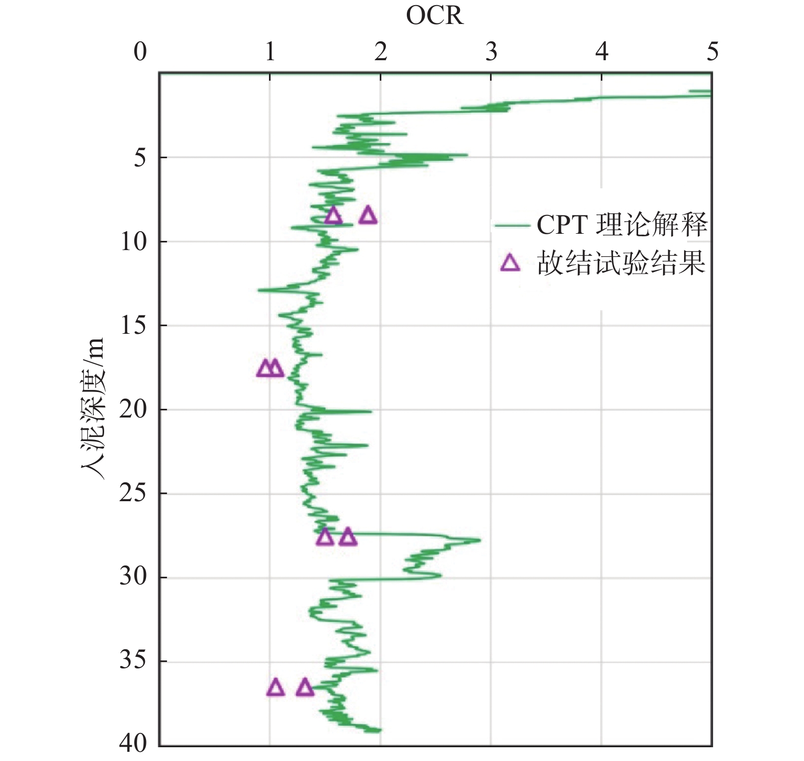
      做为示例,图10显示了某一海洋地勘项目中,上述固结试验与CPT原位测试两种独立方法得到的土体OCR的一致性比较。

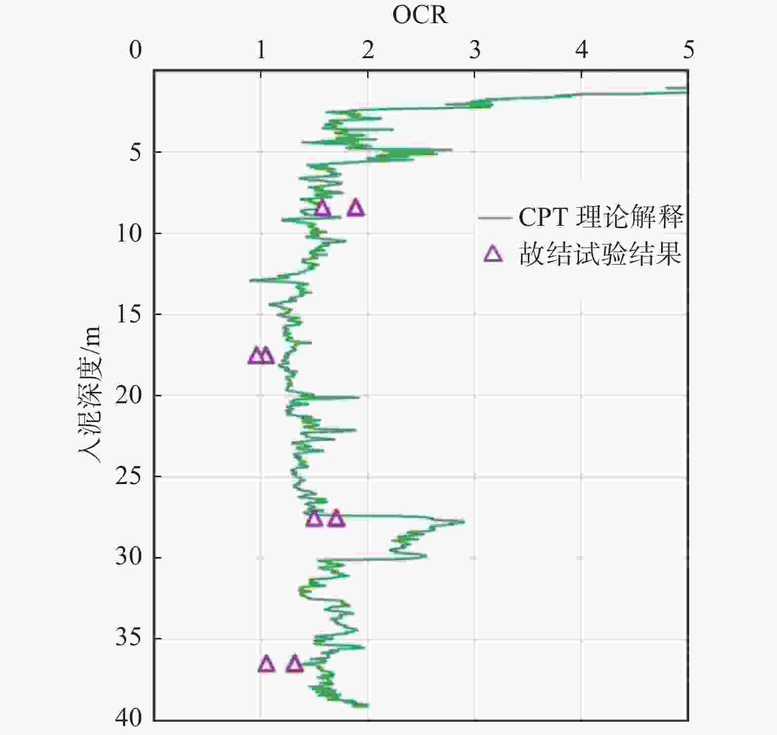
      Figure 10.  Consistency evaluation of soil OCR obtained from consolidation test and CPT in-situ test

    • 土体的不固结不排水抗剪强度Su是各种海洋地勘及工程设计的核心参数。依据SHANSEP方法[5]和临界状态土力学理论[7],土体Su可根据以下公式获得:

      $$ {S_{\rm{u}}} = m \cdot {\sigma '_{{\rm{v0}}}} \cdot {\rm{OC}}{{\rm{R}}^n} $$ (6)

      式中:

      m、n ——无量纲系数,可由一系列SHANSEP测试获得[15,19],当土体受力接近单剪状态时,m值约等于(sinφ/2)[17],而n的典型值通常在0.8左右,且n的变化较小,对最终结果影响不大;

      σv0 ——给定深度处土体的有效上覆压力(kPa);

      OCR ——土体固结比。

      依据以上Su公式,可在室内试验中进行SHANSEP试验,获得土样的超固结比OCR并直接量测m值和n值,此外,也可以根据CPT的测量值,获取土体的OCR和内摩擦角,进而计算土体的Su

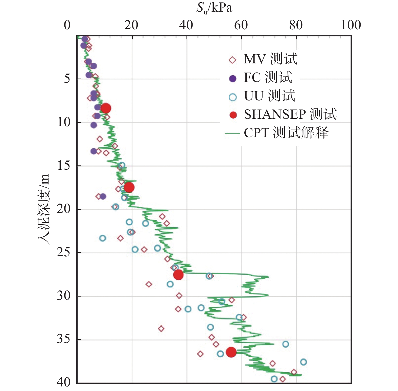
      图11显示某一海洋地勘项目多种方法获得的Su分布比较。图中可见,常规强度试验包括(室内十字板MV,落锥试验FC,以及UU试验)得到的Su离散性较大,且数值相对较低,而SHANSEP高级试验结果及CPT解释结果有较高的一致性。在该项目中,土体强度的设计特征参数将主要依照SHANSEP试验及CPT试验结果来确定,而常规强度测试与“真实值”有明显的偏离。依据图8所示的流程,如果图11所示的地勘数据中再增加原位十字板,则数据的可靠性和精准性将更具说服力。

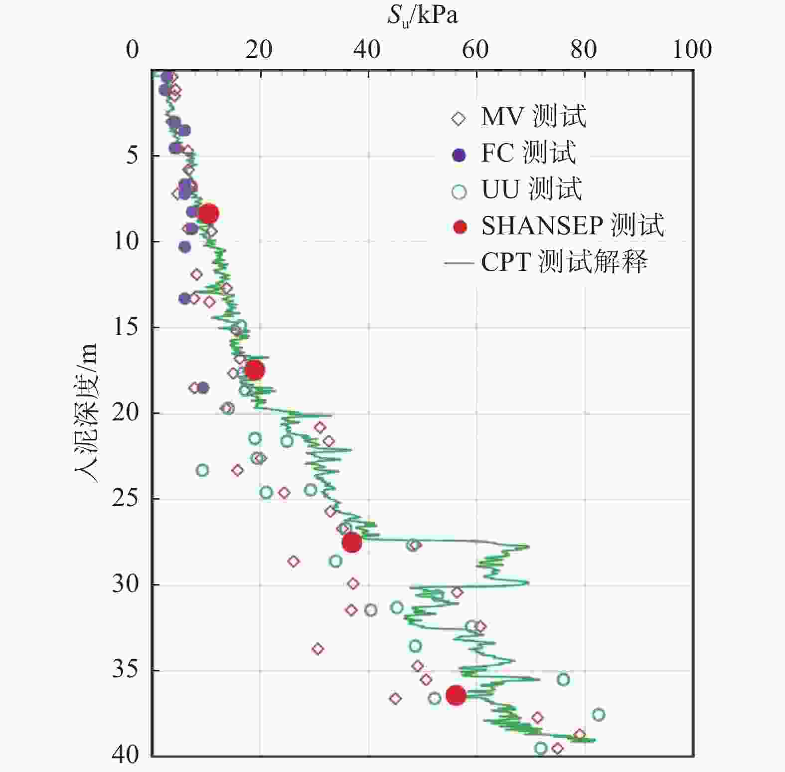
      Figure 11.  Comprehensive test and analysis of soil strength Su consistency

    • 海洋地勘是海洋工程的重要环节,区域性的工程物探、定点式的钻孔取样和原位测试以及地质模型的深度整合是当前国际海洋地勘技术发展的重要趋势,也是精准地勘的重要组成部分。本文已探讨了岩土勘测数据的一致性,基于已有的海洋岩土设计标准,建议偏离允许范围控制在30%之内,从更严谨的角度,控制在20%之内。本文多以黏性土为例阐述了一致性原则,该方法同样适用于砂性土,但公式及参数须根据土的性质作适当调整。

      海洋地勘的一致性还包括另外两个方面:工程物探数据的一致性和工程物探与岩土勘测数据的一致性。在此原则上,基于海洋地勘的本质特征,建立了立体交叉的海洋地勘测试流程,形成多种“独立”方法之间的相互校核,通过校验数据的一致性,辨别数据的偏差,从而对地勘整体数据去芜存菁,保障最终数据的可靠性和精准性,形成精准地勘数据体系。

    • 本文重点介绍了基于多种测试的土样扰动评估方法,特别是在临界状态土力学理论的框架下,把室内土工试验和原位测试相结合,常规土工试验和高级土工试验相结合,发展了以土样强度为代表的岩土参数一致性综合测试分析方法。

      在现阶段为了进一步提高我国海洋地勘可靠性和精准性,实现海上精准地勘,主要建议如下:

      1)加强土工试验数据一致性分析,高质量的土工试验是现阶段保证地勘岩土参数准确的基础,但应意识到海上作业的复杂和样品运输的不确定,取样扰动无可避免,因此建议每个地勘项目应进行土样扰动综合评价。

      2)积极推进原位测试在海洋地勘中的应用,原位测试技术手段不仅包括本文所述的静力触探、还包括旁压仪、十字板剪切等;建立原位测试与土工试验相结合的一致性分析系统。

      3)加大对以一致性为基础的地勘数据分析投入力度;数据分析不仅能对原始数据去芜存菁,保障数据的可靠性和精准性,更能进一步实现勘察工作的降本增效,目前阶段对数据分析重视不足、投入不够。

      4)推进精准地勘在复杂地质条件下海洋工程勘察设计中的应用;以一致性为基础,结合物探、土工、地质模型的精准地勘体系为海工设计提供了全面、立体的地质条件。以海上风电为例,精准地勘在优化风机布置和风机基础设计中有良好的应用效果。

Reference (19)

Catalog

    /

    DownLoad:  Full-Size Img  PowerPoint
    Return
    Return